6/26/2015

Silver City, Idaho

Silver City, Idaho -- A Historical Mining Town

While returning from a rafting trip in northwestern Colorado, we stumbled upon a small ghost town called Silver City, just 50 miles south of Nampa. Silver City originally had its heydey in the 1880s as a gold and silver mining town, and it is still quite intact. In fact, there are many residents who spend the summers there until the road closes for the winter. Some of them are descendants of the original settlers.

Located in the Owyhee Mountains, the town was established in 1864 soon after silver was discovered at nearby War Eagle Mountain. War Eagle mountain is located to the east, and Florida mountain to the west. Both are about 8,000 feet in elevation. It was said that from the summit of War Eagle mountain, on a clear summer's morning, with the aid of a telescope one could see the Teton range in Wyoming and the Wasatch range in Utah.

The Idaho Bureau of Mines and Geology, estimated that $30,000,000 in silver/gold ore was mined from areas around Silver City between 1865 and 1914. Mining was intensive in the area until the failure of the Bank of California in 1875, which stopped most of the work.  One Poorman Mine ore specimen of  proustite ("Ruby Silver") from War Eagle Mountain was so spectacular, it was displayed in Congress and in the Paris International Exposition, where the exhibit received a special gold medal in 1867.

Poorman Mill on War Eagle Mountain from
"A Historical Descriptive and Commercial Directory of Owyhee 
County, Idaho" January 1898

By 1898, the Silver City population was nearly 2,000 people. The town once had hundreds of buildings including eight saloons, six general stores. Having the first telegraph service and first daily newspaper (The Idaho Avalanche and later The Owyhee Avalanche) in the Idaho Territory, Silver City also had a post office, hospital, and was the County seat until 1935. There are still about 75 buildings that remain.


One of the largest buildings we noticed was the old Idaho Hotel built by J.K. Eastman and Hosea B. Eastman in 1866. The owners enlarged the structure over time, adding a bar and porch in 1871 and a woodshed, kitchen and additional rooms in 1873. The hotel was sold several times between 1889 and 1898. It reopened for business in 1970 when it was purchased by Ed Jaegels.

Idaho Hotel

The Masonic Hall was another distinctive building located on Morning Star Street. It was originally owned by Tom Jones and used as a planing mill used to produce lumber for homes and other structures. It was purchased in the mid-1870s by the Masonic Lodge. 

Masonic Hall

Another distinctive building we noticed was an Odd Fellows Lodge built in the 1870s. Originally an apartment house, one of the early owners was Dave Adams who rented out apartments while operating the adjacent general store. The telephone office was located here from 1901 to 1905. It was eventually purchased by the I.O.O.F. and Knights of Pythias who shared the rooms. The Knights of Pythias turned the lower floor into a dance hall and stage for an orchestra. The I.O.O.F. eventually obtained full ownership of the building.

I.O.O.F  Hall

The Meat Market Shop had several owners, the last known operator being Clyde Stoltz. Supposedly, there are still meat racks, hooks and other fixtures inside. A large walk-in box was constructed to provide refrigeration before the days of electricity. Ice was placed in a compartment above the box and under the shop buried in sawdust. Cattle were driven to town from nearby ranches. In the early days, it was discovered that the local bunch grass and white sage produced excellent cattle, and many local ranches were established. In 1898, it was estimated that there were 60,000 head of cattle in Owyhee County (A Historical, Descriptive, and Commercial Directory of Owyhee County, press of the Owyhee Avalanche 1898).

Butcher Shop

On the north side of town off Morning Star Street is the Idaho Standard School, which opened in 1892 and was used until 1934. It was supposedly built from tax revenue from the saloons. It has been restored and now houses a museum of Owyhee County and Silver City memorabilia.

Idaho Standard School

There are several other buildings to explore in this old town, such as the town's last post office location built around 1868 as a residence and discontinued in 1943 during World War II. There is also a brewery vat built by Will Hawes, who lived in Silver City his entire life. He built the vat and added a miniature bar scene inside, which has since been destroyed. If you visit, keep in mind that the buildings are private property and should not be entered unless they are an operating business open to the public.

6/20/2015

Yampa River - Deerlodge Park to Split Mountain

Whitewater Rafting on the Yampa River - Deerlodge Park to Split Mountain

With no major dams and diversions, the Yampa River is considered one of the last wild rivers in the West. It is the longest free-flowing tributary in the Colorado River basin and the largest tributary to the Green River. Its headwaters begin in the White River National Forest of northeastern Garfield County, Colorado. It is joined by the Little Snake River before entering Dinosaur National Monument and ultimately joins the Green River in Echo Park in extreme northwestern Colorado.

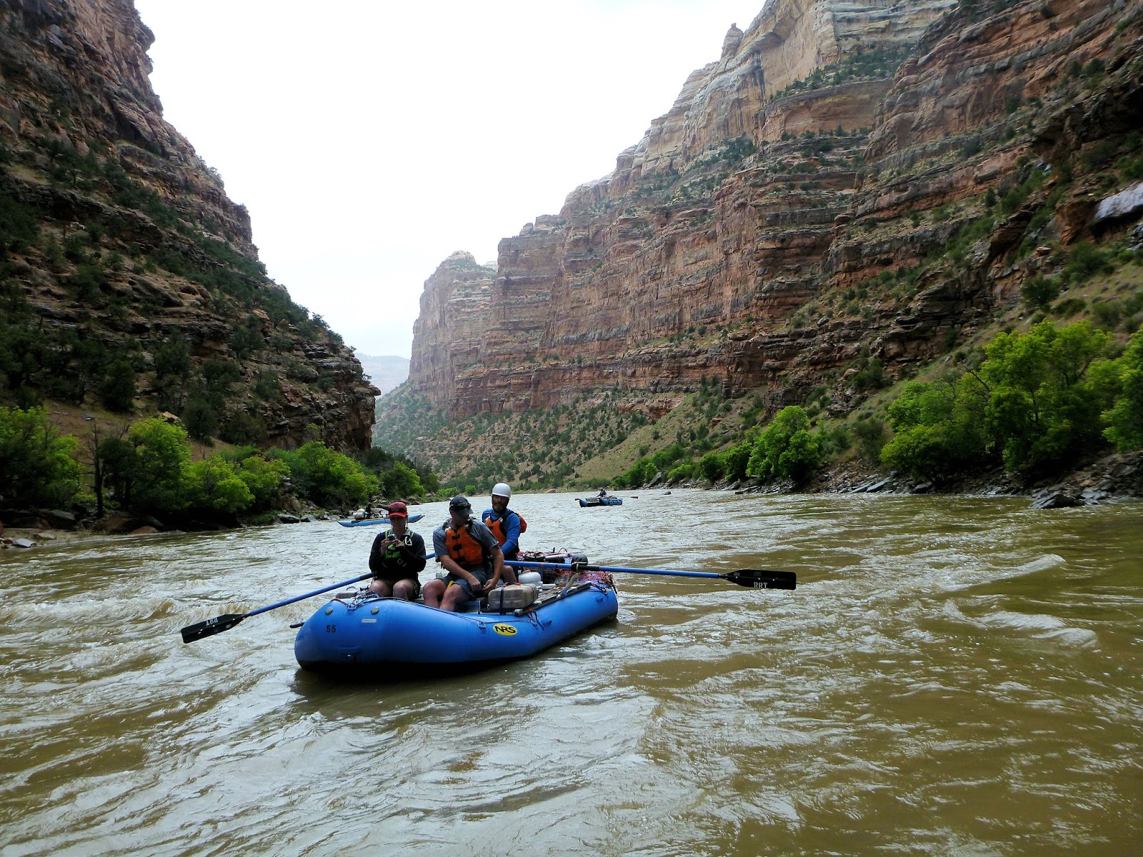
The trip began at Deerlodge Park. From this point, we floated on the Yampa for 46 miles to Echo Park where it joins the Green River. The notable rapids included Teepee Rapid (III), Big Joe Rapid (III) and Warm Springs Rapid (IV).


The Yampa meanders through the Yampa Canyon, with spectacular tilted beds of sandstone. Smooth canyon walls overhang the river in some places towering up to 1,000 feet above the water. We had some rainy weather the first day with a 20 mile float to the first campsite, Big Joe. The weather cleared the next morning giving us the opportunity to explore the area. There were some beautiful rock formations near this campsite a short distance up a small gorge.

Big Joe Campsite

Rock Formations near Big Joe Campsite

The name Yampa is derived from the Snake Indians word for the Perideridia plant --  a tall, grass-like plant in the Parsley family. Yampah was a major food plant of the Native Americans, who would collect its root, dry it, and pound it into a white meal. John C. Frémont recorded the name 'Yampah' in entries of his journal from 1843 (Report of the exploring expedition to the Rocky Mountains in the year 1842 : and to Oregon and north California in the years 1843-44 by Frémont, John Charles, 1813-1890; Torrey, John, 1796-1873; Hall, James, 1811-1898; United States Army Corps of Engineers, Published 1845):
"It grows more abundantly, and in greater luxuriance, on one of the neighboring tributaries of the Colorado than in any other part of this region; and on that stream, to which the Snakes are accustomed to resort every year to procure a supply of their favorite plant, they have bestowed the name of Yampah river."
The second day was a bit rainy again, but short. We stopped to check out a cave known as Signature Cave. There was a lot of graffiti inside the cave made by river runners from the 1930s and 1940s.


Traveling between Big Joe and Mathers Hole Campsites

View from inside Signature Cave

Mathers Hole campsite was beneath a large overhung cliff that is about 500 feet tall. The area beneath the overhang was sheltered from rain and very sandy -- perfect for horseshoes.


A game of horseshoes beneath Mathers Hole overhang

There were additional opportunities for hiking at Mathers Hole. One of the trails led to the top of the canyon for an incredible view of the river below.


View of Yampa River near Mathers Hole campsite

We spotted several types of birds and signs of beavers. The Yampa River is important spawning habitat for the endangered Razorback sucker (Xyrauchen texanus) and Colorado pikeminnow (Ptychocheilus lucius), the largest minnow in North America, which historically reached lengths of 6 feet. Today they typcially reach lengths of 2-3 feet. Other endangered species in the Yampa River include humpback chub (Gila cypha) and bonytail (Gila elegans)  Eighteen non-native fish species have been introduced some of which include channel catfish, common carp, green sunfish, northern pike, red shiner.

The weather cleared on day three from Mathers Hole campsite to Laddie Park campsite. While it was another short day, the scenery was amazing. Photographs do not come close to capturing the spectacular canyon walls, such as the Grand Overhang and Tiger Wall (actually on day 4 between Laddie Park and Sea Cliff Beach campsites).


Grand Overhang

Tiger Wall

En route to Sea Cliff Beach campsite, we arrived at Warm Springs Rapid, the only class IV on this trip. Apparently the rapid was created in 1965 by a flash flood that washed a debris flow down Warm springs Draw. There is a 1,500 foot cliff here, the tallest on the trip, but most folks were focused on the rapid. The main hazard here is Maytag Hole which can flip boats. Not being a fan of class IVs, I was the only person who chose to walk, but all bodies and boats made it through with no trouble.

A film was released by Friends of the Yampa in November 2014 about the Yampa River and formation of the Warm Springs Rapid. Check it out ONLINE.

Shortly before reaching Sea Cliff Beach, we reached the confluence of the Yampa and Green Rivers.

Confluence of the Yampa and Green Rivers

Christi enjoying the scenery with "Wilson"

The next day, we traveled between Sea Cliff Beach campsite and Jones Hole campsite. Near Jones Hole Creek, there were several trails to hike, one of which led to some 1,000 year-old pictographs created by the Fremont people.

Pictographs by the Fremont People

Checking out the pictographs

There was also a waterfall, which we all found to be entertaining (and refreshing after camping for several days)... and bunnies too!

Karen's turn!

A bunny on the trail

Our last night of camping was at Island Park, near "Bug Island".... eh em... I mean Big Island. There were soooo many mosquitos! Everyone dealt with it in good spirits.

Overall it was an amazing trip and a wonderful group. I didn't take many photos on the water, but I'll end with a small clip taken towards the end of the trip. The flow during the trip was between 7,500 and 8,000 cfs, which seemed just great. Because its natural flooding process is essentially undisturbed, this is definitely a precious natural resource to be protected. I feel so lucky to have had the opportunity to have this experience.


5/16/2015

John Day River -- Service Creek to Clarno

John Day River Trip -- Service Creek to Clarno

The John Day River in northeastern Oregon from Service Creek to Clarno Launch is an excellent choice for beginning whitewater rafters. This section is a 48 mile trip that can be completed in 3 days, with only three Class II rapids and one Class II/III. Overall, it is a slow moving river perfect for its scenery, wildlife viewing, and fishing, however, the rapids should not be underestimated, particularly in higher flows. We put in at Service creek in May at a barely runnable flow (around 1,000 cfs). Another (downstream) section from Clarno to Cottonwood contains Class II-IV rapids (Clarno Rapid III-IV) and can be floated in around 7 days.

From Service Creek to Clarno Launch you can expect to float through a substantial amount of disturbed ranch land. However, there are sections with spectacular scenery, particularly in the early morning or late afternoon. Geologic features include colorful painted hills of the Morrison formation, basalt cliffs, and formations from ancient pyroclastic flows.

Basalt Cliffs
The John Day River is the second longest free-flowing river in the contiguous United States, after the Yellowstone River, and the water levels can vary widely depending on the snow pack of the Blue Mountains. Starting at its headwaters in the Strawberry Mountain range, the river flows 281 miles to the Columbia River. You can expect to see a variety of raptors and songbirds. Bald eagles, herons, killdeers, Canada geese, western tanagers are a few of the species we spotted. Bank Swallows nest in huge colonies in cliffs along the river. The video below has footage from one well-used hillside:


The river was named for American hunter, John Day, a member of Wilson Price Hunt's Astoria overland fur trapping expedition of 1811 and 1812. There was evidence of beaver dams all along this section of the river which also provides habitat for many endangered fish species, including wild steelhead, Chinook salmon, and bull trout. The Confederated Tribes of Warm Springs own the Pine Creek Conservation Area at river mile 129, which is managed for wildlife and fish habitat.

Upland view of the John Day River
The Oregon Natural Desert Association is working to obtain wilderness designations for more than 130,000 acres of the river corridor and upland fish and wildlife habitat. This would include a Cathedral Rock Conservation Area of 17,000 acres.

Approaching Cathedral Rock
More volcanic formations
There are many campsites along the river for both groups and individuals. At the time we were there, few boaters were on the river and we had the place mostly to ourselves.

The most notable rapid between Service Creek and Clarno Launch is Burnt Ranch Rapids, which is about 11.5 miles downstream of the Twickenham boat launch and the last rapid you will encounter on this section. In low water, it is a bit rocky and drift boats can grab the rocks.


Overall, this is a relaxing trip and a nice opportunity to see some beautiful landscapes in northeastern Oregon. While we didn't do any hiking, there many places on BLM land to explore.


3/27/2015

Hubbard, Oregon -- A Walking Tour

Hubbard, Oregon -- A Walking Tour

Hubbard is a small community in the Willamette Valley, and if you didn't know it was there, you might miss it driving along Highway 99E. However, it has an interesting history and has been a premier agricultural region since its establishment. The town was named for Charles Hubbard, a Kentucky native, who crossed the plains to Oregon by ox team in 1847. Soon after the Charles Hubbard family arrived in Oregon, they rented a squatter's cabin on the ridge between the Pudding River and Ferrier Creek (also called "Deer Creek" and now known as Mill Creek). That cabin was owned by Thomas Hunt, who left the area on a gold-seeking expedition. He never returned. Subsequently, Charles Hubbard acquired 400 acres of land in and around the present city. The town was named for him because he offered 10 acres of land as an inducement for the Oregon-California railroad, which was under construction from 1868-78. The railroad accepted the offer and was built through Hubbard in late 1871 right after the first store was built in 1870 by Aaron B. Gleason. The Oregon Legislature voted to grant Hubbard a charter and the right to incorporate in February, 1891. As with many towns, the arrival of the railroad spurred development, and Hubbard grew to a population of 500 by 1910.

Old Hubbard Train Depot, early 1900s


Beaver State News 11/9/1911
Several of the original community buildings in Hubbard no longer remain, including the Assembly Hall, community bandstand, "Commercial House" Boarding House, Southern Pacific Railroad Train Depot, and others. The community bandstand was located on the commons in front of the railroad depot. A brass band was organized in 1882 and another assembled in 1911. Although most commercial structures are gone, many homes built by the town's founders remain and have been beautifully restored and maintained. This walking tour is a work in progress and will be updated as additional information becomes available. Dates on the homes require verification.


1. Hubbard Pharmacy Building (1890/95): The focal point of the town is the Hubbard Drug Store Building located at 3569 3rd Street.  Originally opened and operated as the Calvert & Scholl Drug Store, it was later renamed Hubbard Drug Store. Joseph Calvert  eventually sold the building when he became the vice-president of the adjacent State Bank of Hubbard. 

3rd Street in 1965 and 2015


Beaver State News 4/6/1911
Beaver State News 12/8/1910
At the turn of the century, Hubbard was a thriving commmunity with two saloons and a large number of businesses, including a bakery, operated by A.O. Griswell and his daughter, a boarding house, confectionery, hotel, photography studio, meat market, shoe shop, furniture store, millnery, and of course many businesses meeting the needs of local farmers.

Another local attraction was the nearby Wolfer's Mineral Springs owned by George Wolfer. The waters were said to be an aid for arthritis. The mineral spring is located to the West of Hubbard on the east bank of Mill Creek.


From The Sunday Oregonian, November 24, 1912
The Sunday Oregonian November 24, 1912

2. Dr. Edward Schoor House (1920):  The son of Dr. Jacob Schoor of Germany, Edward Schoor (1871-1952) came to Hubbard around the turn of the century after graduating from medical school in Kansas City. He practiced with his father in Kansas City for nine years and maintained an office there for twenty-two years. He relocated to Portland, Oregon, spending six months in that city while passing the state board examination and working as a house doctor for the Hoyt Hotel. After he successfully passed the exam, he moved to Hubbard and married his second wife, a nurse, in 1913. Tragically, she was killed in an automobile accident at a railroad crossing in 1920. Dr. Schoor was seriously injured. He remarried in 1922 and had one daughter. His 11- bed hospital was on G Street between 3rd and 4th Streets.


3. John Scholl House (1890): John Scholl was born in Bethel, Missouri in 1847 and accompanied his parents to Oregon in 1881. He was a carpenter and farmer who moved to Hubbard in 1898 where he purchased an interest in the hardware store of his brother-in-law, George Fry in 1903. He served as a member of the city council and as school director for 12 years. He had four sons, Henry F., George F., Lawrence M. and David J. 


4. Bahne Paulsen House (1917): B. Paulsen (1870-1954) was born in Germany in 1869, and came to the United States in 1870. He lived in Wisconsin for 20 years, in Nebraska for 22 years, and moved to Hubbard around 1911. He was the son of Ebe Christopher Paulsen and Anna (Hilgen) Paulsen originally of Germany. Bahne was President of the Hubbard State Bank, and owned a store called B. Paulsen & Son.


5. George W. Knight House (1905):  In partnership with Peter Susbauer, G.W. Knight (1874- ) operated a department store in Hubbard, Knight and Susbauer. Besides groceries and dry goods, they kept flour, feed, clothing and furniture. G.W. Knight was born in Canby, Oregon to Dr. Charles Knight, a Canby physician who emigrated from Missouri to Oregon in 1871. George was employed for a time in his father's drug store and at age 18 accepted employment with Carlton & Rosecrans, Clackamas County's largest department store. He moved to Hubbard in 1899 and bought out the general merchandise business of George H. Beebe.


6. Lawrence M. Scholl House (1908): L.M. Scholl (1875-1963) was born in Aurora, Oregon. His parents and grandparents were members of the Keil party from Bethel, MO. His father, John Scholl, was a carpenter and farmer who relocated to Hubbard from Aurora in 1898. In 1903, John purchased part interest in George M. Fry's general merchandise business with his elder son George F Scholl. Lawrence Scholl attended Portland Business College, graduating in 1898, and was appointed assistant postmaster in 1900 under J.L. Calvert. This house was built entirely of lumber from the nearby sawmill at Scotts Mills, which was freighted on the railroad to Hubbard. 


7. George W. Dimick (1913): G.W. Dimick (1837-1918)  was the son of one of the oldest pioneer farmers of the Willamette valley, Augustus R. Dimickwho had been a big factor in the growth of the agricultural and livestock industries in Hubbard. He brought his family across the plains to Oregon in 1847. Augustus Dimick is noted for bringing potato seeds for “early or shaker blue” potatoes from Michigan and planting them throughout Northern Marion County.  They were nicknamed “Dimick Potatoes.” George Washington Dimick and brother J.B. Dimick had, by 1878, taken over the ownership of much of the original land claim of their father, Augustus. George W. owned and managed an apple orchard, grain, and livestock farm of over a thousand acres near Hubbard. He was a stock breeder Short-horn and Aberdeen cattle. He was also active in politics and was an organizer of Oregon's Prohibition party. He eventually retired from farming and moved to Oregon City. 


8. J.L. Calvert House (1895):  The Daily Capital Journal (April 13, 1910) referred to Calvert as being "almost the father of the town." He was born in Clackamas County in 1856 and moved to Marion County with his family around 1863. They settled on a farm between Woodburn and Gervais. In 1877 he became employed in Gervais as a clerk in a drug store. He opened his own drug store in Hubbard in 1881 and operated it for almost 30 years. He sold the business in 1910 and, as one of the organizers of the adjacent Hubbard State Bank, worked as a cashier and director there until 1915. He held several official positions from postmaster, county recorder, justice of the peace, and road supervisor to representative in the state legislature.

9. George M. Fry House (1908):  Prior to their deaths in 1849 and 1854, George Fry's parents had moved their eight children from Pennsylvania to Bethel, Missouri where they joined William Keil's Christian communal society. An orphan at age 12, George (1842-1917) migrated to Aurora, Oregon in 1863 along with Keil's followers. George remained a member of the colony becoming a jeweler's apprentice. Once he learned the trade, he relocated to nearby Hubbard in 1887 and established a jewelry store there. In 1890, he acquired a general merchandise store in partnership with Harvey A. Hinkle. The business was operated under the name of  Fry & Hinkle, until Mr. Hinkle sold Fry his interest in 1893. Once established and profitable, Fry sold the business to H.A. Beebe in 1896 and opened a hardware store in partnership with John Scholl, selling his interests to George Scholl after three years. He built a warehouse which he operated until 1911 when he retired owning 200 acres and several residential blocks of Hubbard. G.M. Fry was also involved in handling his sister's (Elizabeth Fry Proebstel [1833-1911]) 800-acre estate. Ms. Proebstel was a wealthy widow of land owner Wendell Proebstel. She is said to have built a pretentious home in Hubbard on the corner of 4th and A Streets in 1880, which was later remodeled into an apartment house. That structure no longer remains. The G.M. Fry family included wife, Caroline, son Frank W. and daughter Sarah A, wife of George's former business partner Harvey A. Hinkle.  


George M. Fry and Family

10. Winfield Scott Zachary Buchanan House (1887): W.S. Buchanan (1847-1919) was a pioneer from Henderson County, Illinois who traveled to the Washington Territory by ox-team in 1854 with his father, George Washington Buchanan, and family. They settled in Lewis, Washington for many years. He relocated to Marion County and built this home with his wife, Susan M.


11. Dr. Samuel W. Weaver House (1895): Dr. Weaver came to Hubbard in 1886 to practice medicine. He was a physician and surgeon and received his training in Pennsylvania. He was born in 1853 and received his education in the College of Physicians and Surgeons in Baltimore, graduating in the class of 1882. He began his practice in Washington County, PA where he remained for two years. He then practiced in Paradise Valley, Nevada for two years before moving to Hubbard in 1886. He was also an accomplished violinist and made several violins. He married Alice Grim, daughter of Judge J.W. and Frances E Grim. They had two children, Frances E and Guy G.


The Weaver House in 1965 (Historic Images of Oregon)

12. The Armory Building (1892): In the late 1880s a group of investors constructed the Hubbard Armory for Company E, Second Regiment of the Oregon National Guard, which disbanded after the war in the Philippines.  The major stock holder was G.W. Dimick, who sold the building to the city a few years later. It became the city hall and community center hosting various public events such as ice cream socials, poultry shows, funerals, Hubbard High School performances, and city council meetings. 


References:

  1. The Centennial History of Oregon 1811-1912 by Joseph Gaston. S.J. Clarke Publishing Company, Chicago (1912).
  2. Daily Capital Journal (various)
  3. USGenWeb and Ancestry.com
  4. Portrait and biographical record of the Willamette valley, Oregon, containing original sketches of many well known citizens of the past and present, Oregon, Chapman Publishing Company (1903) 
  5. The Bulletin. Volume IX, Number 39, September 24, 1980, Molalla, OR.
  6. Woodburn Independent, June 30, 1976.
  7. The Beaver State News and Hubbard Herald (various dates between 1907 and 1912).