Showing posts with label oregon. Show all posts

10/29/2022

Upper and Lower O'Brien Creek Trail

As the crow flies, the O'Brien Creek Trail #900 is situated about 7.7 miles directly south of the town of Williams, Oregon. It is possible to begin hiking at the lower trailhead, or continue driving to the end of the Forest Road 1005 and begin at the Upper O'Brien Creek trailhead. Hiking both trails with a couple of short diversions, we logged 7.1 miles and an elevation gain of 2,303 feet. The lower trail closely follows O'Brien Creek although the best view (from the trail) on this stretch is right at the trailhead.  

The lower trail winds through lush riparian habitat, and the tranquil sound of the water tumbling down the rocky mountainside is constant. The area burned in the 2017 Creedence Fire, which began with a lightning strike. The fire burned approximately 2,093 acres on both sides of the divide, including portions of O’Brien Creek.


Hydraulic mining occurred in this area during the late 19th century. According to a 1996 Department of the Interior publication (Stories on the Land: An Environmental History of the Applegate and Upper Illinois Valleys), O'Brien Creek water was diverted for mining via a ditch that is currently used to divert irrigation water to Thompson Creek. Some of the area around O'Brien Creek was reportedly harvested for timber in the 1950s. Forest Road 1005 which leads to O'Brien Creek was constructed in the late 1950s through the 1960s by timber purchasers (Rogue River-Siskiyou National Forest Roads Analysis 2004). The creek was reportedly named for John O'Brien, farmer and stock raiser born in Galway, Ireland. He apparently trailed cattle from his lower Applegate River ranch to the meadows in the Grayback Mountain-Sugarloaf Peaks area. John came to the region in 1852 and was said to have found a pocket of gold worth $28,000. He spent all of the money digging a 13 mile diversion ditch out of O'Brien Creek to work the deposit (Notes on Historical Events as related by Ranger Lee Port, Rogue River Historical Information, Applegate Ranger District, 1943).


According to an Applegate Watershed Assessment prepared by the Applegate River Watershed Council in 1994, O'Brien Creek and nearby Sturgis Creek were once widely-known as blue-ribbon trout streams; however, few large fish are present today. The report states that some populations of cutthroat are present in remote headwater areas. The upper trail continues along the creek until a split that leads to the Grayback Snow Shelter (a cabin that was used before snow surveys were automated). Take a right to continue on towards Boundary Trail.


At this point, the trail leaves the creek and winds up the slope toward the Grayback Mountain and the intersection of Upper O'Brien Creek trail, Boundary Trail and Grayback Mountain Trail.


The upper trail continues through the forested slope, passing through areas containing evidence of bears and examples of soil creep.


At the junction with the Boundary Trail, there is a sweeping view of the Grayback Mountain slopes with Mount McLoughlin in the distance. From this point, the trail will split toward Grayback Mountain Trail (to the north) and Boundary Trail (to the south), which is a 15.6 mile ridgeline trail that travels through high mountain meadows and divides the Illinois, Klamath, and Applegate drainages.

10/23/2022

Devil's Peak in Sky Lakes Wilderness

In 1984, Congress approved designation of the Sky Lakes Wilderness, a 181-square-mile area in the southern Oregon Cascades. It is situated within the Rogue River–Siskiyou and Fremont–Winema national forests and contains more than 200 pools of water formed when glaciers retreated from the area. The lakes are concentrated in four main lake basins: McKee, Blue Canyon, Seven Lakes, and Sky Lakes. According to the U.S. Forest Service, Lakes Alta and Natasha in this basin were found in an EPA study of acid-rain conditions in Western U.S. mountain lakes, to have among the most chemically pure water in the world. Glaciers formerly covered this area in three glacial lake basins: Sky Lakes, Seven Lakes and Blue Canyon.
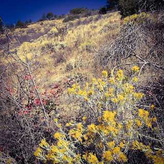
The journey begins on Seven Lakes Trail #981 which leads you through an understory filled with huckleberry shrubs. Tree cover is mostly Shasta Red fir, lodgepole pine, and mountain hemlock with whitebark pine in the higher elevations. Although rarely seen, the American three-toed woodpecker (Picoides dorsalis) reportedly uses the area according to a 1987 Draft Environmental Impact Statement. These birds are often near high elevation lakes and feed on bark beetles. The lower trail from the forest road to Frog Pond is heavily damaged from equestrian use, so this stretch is loose rock and slow going.  

You will pass Frog Pond on the right, shortly after which you reach the trail junction for Devil’s Peak Trail #984. Once you reach the turn off to Devil's Peak, there is less damage and the hike is more pleasant. 

After the turnoff, you will eventually enter a large block field where there is a distant view of the wilderness area. Block fields are large areas of angular rock that have been created by regular freeze-thaw activity fragmenting exposed rock. Many of the rocks are massive and the slopes are fairly steep; however, the trail is clear.

After the block field, the trail is again smooth until the immediate ascent to Devil's Peak. It is not a difficult ascent although the best views of the lakes to the north are seen from the saddle at around 7,300 feet elevation. The summit, has an incredible view in all directions including Mount Shasta, Upper Klamath Lake, Mount Thielsen, the Crater Lake rim, neighboring peaks Lucifer, Juniper, Venus and Lee. The north face of Devil's Peak is a sheer cliff.


Remnants of a former Forest Service lookout were visible during our visit. According to a August 23, 1959 story in the Medford Tribune, the live-in lookout was built in 1930 and supplied by pack train every two weeks. The person stationed at the lookout hiked two miles down the trail to neighboring Lee peak every morning for water until the pack train began hauling it in. The lookout was reportedly destroyed in 1968. 

10/18/2022

Boundary Springs Trail - The birthplace of the Rogue River

This is an easy to moderate hike. It begins at the Mount Mazama viewpoint off Highway 230 and follows the Rogue River (5.4 miles roundtrip) to its headwaters at Boundary Springs. Our elevation gain was only 759 feet, so it is fairly flat. The headwaters consist of a beautiful, moss covered, crystal clear spring that rushes out of the hillside. In July, the logs are apparently covered in monkeyflowers; however, they had faded at the time we visited in mid October. The water source was formerly believed to be Crater Lake, but it has been determined that it is actually from rain and snowfall that percolates through the volcanic pumice and travels laterally toward the springs along a less permeable rock layer beneath.

Be aware that after about a mile into the hike, the trail intersects a Forest Service road. Turn right and head up the road for about 75 feet before turning left, back onto the Boundary Springs trail. Central Oregon Geographica provides a very nice map and trail summary. In 2015, the area was burned by the National Creek Complex Fire. However, there were signs of recovery with pine seedlings covering the landscape. Pines apparently do better than firs in hot fire-prone areas.

The hike is exciting in that it winds along the river, ultimately leading to its source. At the time, the pearly everlasting were releasing their seeds and leaves were beginning to turn fall colors.


As you travel upstream, the trail crosses the narrow river at two points. Eventually, you will encounter a section where it tumbles down a small double waterfall which is located a short distance downstream of the springs. This area is reportedly territory of the American dipper (Cinclus mexicanus), a bird that forages in whitewater. It is also know to walk underwater!


Eventually, you will reach the intersection of the Boundary Springs Trail and Bald Crater Loop Trail. Continuing on the Boundary Springs route, the water tumbles through a marshy, log-covered channel on your left. The trail ends where the water pours from the hillside into a watercourse several feet wide. Physical disturbance of the plants in this sensitive location would be harmful due to the unique presence of water here in the summer months. Summer water is otherwise scarce in this area. The crystal clarity of the water is remarkable.  

I think there is an even greater appreciation of this location if you are familiar with the Rogue River farther downstream. The river provides drinking water for over 200,000 people, recreation, and habitat for fish and wildlife. It is so important that it is protected. Since 2008, eight dams have been removed from the Rogue River and its tributaries including Gold Ray (2010), Savage Rapids (2009), Gold Hill (2008) on the main stem. The river now runs free for 157 miles from Lost Creek Lake to the Pacific Ocean at Gold Beach. The last dam standing is the William L. Jess dam, constructed in 1977 for flood control, which impounds Lost Creek Lake.

2/19/2022

Carberry Creek Quadrangle Hikes

 Collings Mountain Trail 

From Watkins Campground, this trail leads toward the Collings Mountain summit then skirts around, heading back down towards the highway and the curiosity known as the "bigfoot trap." There is a modest view of Applegate Lake, but there are no spectacular viewpoints to mention. On an unseasonably warm day in January, we hiked an out-and-back from Watkins Campground to the summit. Here are the statistics for the ascent only:

Distance: 2.86 miles
Duration: 45 minutes
Minimum Elevation: 2129 feet
Maximum Elevation: 3458 feet
Approx. Elevation Gain: 1376 feet
Other trail users seen: 0


11/18/2021

Sterling Creek Quadrangle Hikes

Jack Ash Trail

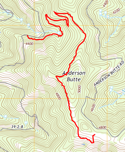
This is a large trail system known as the Jacksonville to Ashland Trail, or "Jack-Ash Trail." Since 2009, the trail has been a project of the Siskiyou Upland Trails Association and is partially completed. We divided our exploration of the trail into three sections, Lower, Middle and Upper Jack Ash Trail, shown in the map below:


Jack Ash Trail, Lower Segment

We had fun snowshoeing on the Lower segment over the holidays. This section is a moderate climb with decent views through the trees. We didn't encounter any other hikers. The trail is accessed from Griffin Lane, named for pioneer Captain B. B. Griffin who settled in the Rogue River Valley in 1852.


Jack Ash Trail, Upper Segment 

This Upper segment was part of Phase I of the Jack Ash trail and opened in 2017. Phase 2 will connect to the Jacksonville, Ashland, and Applegate Ridge Trail systems. Here are our statistics for this hike which can also be accessed by Anderson Butte Road:

Distance: 3.4 miles
Duration: 1 hours, 22 minutes
Minimum Elevation: 4269 feet
Maximum Elevation: 5019 feet
Other trail users seen: 0


9/25/2021

Squaw Lakes Quadrangle Hikes

Little Grayback Trail # 921 

This trailhead is about a 40 minute drive from Jacksonville and is accessed by Forest Service Road 490. There is a short drive from the Forest Service Road to the trailhead. More details on the 5.4-mile hike (10.8 total miles) are available from the U.S. Forest Service and other websites below. It's an out-and-back hike with an elevation gain of 1,800 feet. 

The trail is lightly used, although it appears to be open to OHVs. It winds through a wide range of land forms, including closed forest and glades. It's a nice late season hike due to the sun exposure. We noticed some buggy conditions in the lower part of the trail and several late season butterflies including fritillaries, satyrs, skippers in the open areas. There is no water on the trail. Additional links to this hike:


Da-Ku-Be-Te-De Trail # 940 

We only hiked a small part of this trail in early October. The full trail is 4.8 miles and ends at Watkins Campground. The area looks as though it would be crowded during peak months and higher water. The Applegate Lake was only 19% full, which made for very steep slopes along the trail's edge. There are beautiful views of the lake, but the hike is flat and it probably gets heavy use in the peak months.  Additional links to this hike:

Charlie Buck/Baldy Peak Trail #918

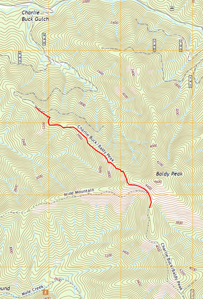
This trail is a steep one, so be prepared and take plenty of water. It would be quite hot in the summer as there are a lot of exposed areas, but it was perfect in mid November. The views are amazing and the steep climb keeps the traffic down. According to the McKee Bridge Historical Society, Charlie Buck was one of seven children of William and Matilda Buck, who came to the Little Applegate from California in 1874. The Charlie Buck Trail is located on Baldy Peak where the family grazed cattle. Additional links to this hike:


Here are the statistics for our hike, which I measured only on the descent:

Distance: 1.6 miles
Duration: 35 minutes
Minimum Elevation: 3088 feet
Maximum Elevation: 4339 feet
Other trail users seen: 0


3/24/2020

Lower Table Rock - A Southern Oregon Hiking Treasure

Upper and Lower Table Rock are very special natural resources in Southern Oregon. It is possible to hike up both for spectacular views of Sams Valley and Mount McLoughlin. They are also sensitive habitat due to the presence of vernal pools, which are seasonal wetlands that provide habitat for distinctive plants and animals found nowhere else. These species have adapted to the unusual "flood and drought" habitat conditions of vernal pools. Most of the historical vernal pool habitat has been destroyed. According to the Oregon Fish and Wildlife only 23 percent of Oregon's original vernal pool habitat in the Agate Desert remains intact. Being a designated area of critical environmental concern, it's important to remember to stay on the trails when visiting.

The hike to the summit of Lower Table Rock winds through mixed oak woodland and Oregon white oak savanna and chaparral ecosystems. Heavily grazed for an extended period, efforts are underway to restore these areas to the characteristic open habitat of the fire-adapted ecosystem. The trail begins off Wheeler Road. From Central Point, head east on East Pine Street about one mile and turn north (left) on Table Rock Road. Drive eight miles to Wheeler Road and turn west (left). The trailhead is about 0.5 miles on the left. There is no parking fee.  


The hike is 3.5 miles round trip gaining about 780 feet in elevation. The difficulty class is Class 1, Easy. Most of Lower Table Rock was dedicated as a nature preserve in 1979 by The Nature Conservancy.  Both the Upper and Lower Table Rock buttes are horseshoe shaped. According to the Bureau of Land Management,

About 7.5 million years ago, a shield volcano erupted near Lost Creek Lake and spread lava over the entire valley. This mass of lava caused the valley floor to rise in elevation to the height of the Table Rocks. Over millions of years, the ancient Rogue River meandered through the valley, eroding and carving away approximately 90 percent of the lava rock. What remains are a few solitary large rock masses, or monoliths, and two horseshoe-shaped mesas known as the Table Rocks.

Shield volcanoes are a type of volcano usually composed almost entirely of fluid lava flows. The lava has low viscosity which means it flows easily and forms low angle slopes.


An old airstrip is visible on the summit, which was closed in 1980. John Day, a local rancher, built the airstrip in 1948 to impress visiting celebrities from Hollywood. He intended to sell residential lots to celebrities who would use the runway.

Airstrip

This area of Southern Oregon is the traditional homelands of the Takelma tribe. The land between Upper Table Rock and Evans Creek was a temporary Indian Reservation between 1853 and 1856. The Table Rock Reservation was created by treaty in 1853 when Rogue River tribes ceded millions of acres of land to the United States in exchange for peace, safety, and a permanent reservation. Before a permanent reservation could be established, the Native Americans remained at Table Rock. However, they became a target of continued acts of genocide by settlers in the region. Because of this, they fought a series of battles and were forced onto the Grande Ronde in the western Willamette Valley. The peaceful tribes who remained on the Table Rock Reservation were marched over 300 miles to the new reservation between February and March 1856.

This is one of the most popular hikes in the Medford area with an estimated 50,000 visitors per year. Guided hikes are available through the BLM's Table Rock Environmental Education Program which posts a schedule. Hikes are on weekends in April and May and are free to the public with reservations required. Schedules are posted in March.

View of Upper Table Rock and Mount McLoughlin