3/08/2018

Taverns in Historical Buildings -- Southern Oregon

While the first Euro-American settlers came to southern Oregon as trappers, urban development in Southern Oregon was initially driven by the California Gold Rush. Many Oregon prospectors streamed to the area from the Willamette Valley in 1848-1849 after word of a gold strike at Sutter's Mill spread throughout the country. Additional discoveries in the Illinois Valley (known as "Sailor's Diggings"), Waldo, Rich Gulch, and Althouse established the importance of the area as a gold mining region. A small mining camp at the head of the confluence of Jackson and Daisy Creeks quickly developed into the town of Jacksonville, and the town was named the county seat in 1852.

There's a lot of history to explore in the Rogue River Valley, and having a solid list of pubs while visiting the area is essential. What's even better is visiting an establishment that is situated in a historical landmark. We've scoured the area for some the best pubs in historical buildings to try.

1. Homestead Pub & Restaurant (119 E Main Street in Rogue River). Originally named Woodville, the town of Rogue River began with a river crossing, known as Evans Ferry, along the California-Oregon Trail. The ferry was set up during the gold rush days of the 1850s. When Mark Whipple opened the Homestead Tavern in 1906, he had a booming business until Prohibition was enacted in 1914. The tavern was converted into a grocery store, cafe and real estate office until 1933 when Prohibition was repealed. Ward Wills, who ran the cafe, converted the market back into a pool hall and bar and named the entire complex the "Homestead" in 1935.

Historical Image from "Rogue River" By Cheryl Martin Sund

The Homestead Pub still has the large neon "H" sign that was added in the 1960s.  Currently the Homestead bills itself as a pub AND restaurant even though it still appears to be more the former than the later. The bar has live music weekly with shuffleboard and pool tables. The menu was standard pub fare, burgers, sandwiches (with excellent French fries), but slim pickins' for vegetarians with only one option.  There is full bar with about 8 beer taps that are dominated by Bud-Miller-Coors monopoly however they do offer a couple good local craft beers.  The friendly clientele is what you would expect from any Southern Oregon dive bar, gravelly-voiced eye-patch-wearing grandmas rubbing elbows with local pot farmers.


2. J'ville Tavern (125 W California Street, Jacksonville). Built in 1856, the J'ville Tavern at 125 W California St, Jacksonville was originally a general merchandise store named Anderson & Glenn General Merchandise. One of the first merchants to sell supplies to the area's gold seekers, John Anderson established his business in this small, rectangular fireproof brick building. The store survived two of Jacksonville's major fires in 1874 and 1884. Anderson joined in partnership with James Glenn, large landowner and town treasurer, in 1859. The men continued to operate a dry goods store here until 1866 or 1867, when the business became Glenn, Drum and Co. In the 1870s, the business operated as Martin and Drum, and then as White and Martin. However, John Anderson maintained ownership of the building until 1877 when it was sold by his widow to Louis Solomon. It was used continuously as a merchandise store until the turn of the century.

Bird's Eye View of Jacksonville 1883 from the Library of Congress

While several businesses have operated here, the J'ville Tavern is currently occupying the building.


Inside, the J-ville Tavern has a full bar, friendly staff and a very respectable tap line-up.  This is not really a place to get food, just more of a watering hole to escape the scorching summer heat or to rehydrate after a day of hiking/biking the surrounding hills.  Hundreds (thousands?) of dollar bills have been pinned to the ceiling by various customers.  The bills are apparently harvested once per year with the money going to a local charity.  Pretty cool. 


3. Grape Street Bar & Grill (31 S Grape Street, Medford). 
In the early 20th century this site on Grape Street (29 and 31 Grape St.) was occupied by a large building used as a livery stable with a blacksmith shop. The Grape Street Bar & Grill building, formerly known as the Davis Storage Warehouse, was most likely was constructed in 1921 after a fire in the old West Side Feed & Sale Stable next door. After construction, the Davis Transfer and Storage Company operated a moving and shipping business here and in the adjacent stable building until the mid-1930s. During WWII, the buildings operated as the City Transfer Company. These two companies (Davis and City Transfer) were among the three or four transfer businesses that existed in Medford at that time. Orchards and ranches relied heavily on them to transport their produce and supplies to and from the railroad freight depot. The building was eventually sold and used as an automobile garage from the mid-1950s through late 1970s. It still has an industrial look with large multi-pane windows and central bay.

The West Side Feed & Sale Stable Building next door at 29 Grape Street in 1909 (National Park Service)
Building front as it looks today with the West Side Feed & Sale Stable Building next door

Interior with exposed brick walls
Today the newly opened Grape Street Bar and Grill occupies the space in addition to a nice patio out-back.  This is a great place to grab a pint and a bite to eat.  Grape Street has a full bar with about 20 really good (mostly Oregon and California) micro brew taps.  The Happy Hour specials here are the best around with dollar off drinks and two dollars off appetizers.  The garlic fries are pretty awesome.  There is live music on the weekends and Tuesdays.  The Tuesday sessions alternate between either blues or jazz.


4. Climate City Brewery (509 SW G Street, Grants Pass). 
The original use for the Climate City Brewery building was.... a brewery! The Grants Pass Brewery was first established at this location in 1887 by William Neurath who built it near his well adjacent to Gilbert Creek. Neurath sold the brewery’s rights to Eugene and Marie Kienlen in 1891 who emigrated from Minnesota. The original building was wooden, which was destroyed in the 1902 fire along with many other buildings on G Street. Kienlen rebuilt the brewery with fireproof brick. Kienlen transferred the property to his wife in 1904 after he learned of a serious illness which took his life that same year. Marie held the business until 1908, when Grants Pass passed a local prohibition ordinance. The business subsequently closed down. Other businesses operated here including a saddle and harness store, a granary, grocery store, warehouse, art gallery, and restaurant.

Grants Pass Brewery Historical photo from "Grants Pass" by Joan Momsen and Oregon Brew Lab
1890 Sanborn Map depicting Grants Pass Brewery

Today, you can still dine and drink some locally brewed craft beer on a comfortable patio situated next to Gilbert Creek. If you choose to stay inside, you'll enjoy dining in a rustic atmosphere with tall ceilings, exposed duct work, wood beams, and exposed brick walls.


Acacia Cooper started as brewmaster at Climate City in May 2016. There is an extensive list of house beers available currently including (as of this writing):

Rainie Falls Red ABV 5.5%, IBU 50
Bigfoot Bourbon Porter ABV 6.6%, IBU 32
Fireside Dark Ale ABV 6.8%, IBU 37
Citrodora Strong Ale ABV 6.9%, IBU 37
Hyperion Porter ABV 6.5%, IBU 32
Hot Shot Smoked Helles ABV 5.1%, IBU 28
Winter Wonderbier  ABV 7.6%, IBU 20
Takilma Kolsch  ABV 5.0%, IBU 28
Nookie IPA  AVB 7.2%, IBU 80
"No Stout About It" Stout  ABV 5.6%, IBU 26
Savage IPA  ABV 7.0%, IBU 90
River Town Brown ABV 5.0%, IBU 20
Maracuya Gose ABV 4.5%, IBU 18
Ray's Imperial Red ABV 7.2%, IBU 53
Powerhouse 100 Double IPA ABV 8.2%, IBU 100
Roguator Dopplebock ABV 7.0%, IBU 33
Yellowbelly Blonde ABV 5.4%, IBU 21
French Roast Coffee Stout ABV 5.6%, IBU 26

Happy Hour food is served Tuesday-Friday from 3pm-6pm.  On weekdays Climate City has one of the best lunch specials around:  ten bucks for a burger, fries and a pint!

5. Omer's Restaurant (1380 Siskiyou Blvd, Ashland). 
Located near the Southern Oregon University campus, Omer's Restaurant is part of Ashland's history as its oldest restaurant and first public cocktail lounge. The restaurant, opened in 1946 by Omer and Hazel Hill, was built by the owners themselves. They planned to call it "Omer's" but the sign painter incorrectly spelled it as "Omar's."

When you step inside it's like stepping back in time. The booths and Formica tables may even be original. While the restaurant has changed hands, the restaurant's website provides some background on the original owners.


According to a Jefferson Public Radio story, Ashland’s mayor encouraged Omer to open a cocktail lounge in the 1950s because the Elks Club and a few other places served only beer and wine and shut down early. The vintage signs are still in use and the building hasn't changed much since then.


2/24/2017

Mexico City and the Free and Sovereign State of Oaxaca, Mexico

Birding, Ruins, and More in Mexico City and the Free and Sovereign State of Oaxaca, Mexico

We flew to Oaxaca, Mexico to escape the wettest February on record in Portland, Oregon. The warm temperatures and sunshine were a relief from the damp sunless days. We love Oregon, but it's always nice to have a break in late winter. We started the trip in Mexico City, staying in a borough called Coyoacán. It is a quiet neighborhood with cobblestone streets and Spanish colonial buildings. It's also the location of the Frida Kahlo museum, arguably the most popular destination. The line was so long all day long that we decided to skip it and visit the former home of Russian Communism theorist, Leon Trotsky, which was a few blocks away.

Frida Kahlo Museum

Leon Trotsky was granted asylum in Mexico after being forced into exile by Josef Stalin in 1929. Trotsky and his wife first lived in the blue house with Kahlo and Rivera. But, after a falling out about a year later, they moved to a nearby home, built like a fortress with a watch tower and guards' quarters. It was fortified to protect him from assassins.

A Marxist, Trotsky popularized socialist ideas and helped organize the South Russian Workers' Union. He was sent to prison where he met other revolutionaries. He and his wife were sentenced to exile in Siberia, escaped, and moved to London where he wrote for a political newspaper of Russian socialist emigrants (Iskra). The couple eventually divorced. Trotsky met Natalia Ivanovna Sedova and  remarried. He continued to write for socialist newspapers in various countries, being deported multiple times and again returning to Russia to support the Russian Revolution of 1917 which ended the monarchy. A new government was set up with Leon Trotsky as foreign commissar. Trotsky eventually resigned the position was appointed People's Commissar of Army and Navy Affairs in which he gained full control of the Red Army. When Lenin died, Stalin aligned with others against Trotsky. He was expelled from the Soviet Union to Turkey, then France, Norway, and ultimately Mexico. He was killed in 1940 by Russian assassins.

Trotsky lived in this Coyoacán house until his death. The construction of the house began in 1903. It was originally owned by Mr. Antonio Turati as a country residence. It had a large garden, watch tower, and T-shaped residence. Trotsky rented the property after doing some remodeling and fortification and moved in on May 5, 1939. In April 1940 he purchased it with funds from the Socialist Workers' Party of the United States.

Trotsky Residence

After purchasing the home, Trotsky made modifications such as raising the level of the walls around the garden, building a guard tower, a guard house, chicken coop and garage.

Dining Room

The house has seven rooms: the kitchen, the dining room, a bathroom, the study of Trotsky, the office of Natalia and the secretaries, the bedroom of the grandson and the bedroom of Trotsky and Natalia. The Mexican government purchased the home after Trotsky's death in 1940 and his wife lived there until her death in 1962.

Trotsky Grave Site

After touring the house, we took a taxi to the Zócalo, or main square. We started a walking tour at the Palacio Nacional, which was closed for the day. We had seen this during a previous trip, so we started instead at the Metropolitan Cathedral of the Assumption of the Most Blessed Virgin Mary into Heaven. Built in sections from 1573 to 1813, the cathedral sits on top of a sacred Aztec site. Conquistadors used stones from the destroyed temple of the Aztec god of war to build it.
Cathedral of the Assumption of the Most Blessed Virgin Mary

Next we visited the adjacent Templo Mayor, which is an excavation site for one of the main Aztec temples of Tenochtitlan (the Aztec capital city). The main shrine on this site stood 150 feet high, but it was demolished by the conquistadors who used the stones to build the adjacent cathedral. The Archaeological Institute of America provides a good description of the site. In 1978, electrical workers discovered a large stone disc carving of the Aztec moon goddess Coyolxauhqui. The city subsequently tore down the colonial buildings and began excavation of the ruins. The museum at the site contains findings from the excavation, but we didn't have time for a tour.

Templo Mayor

We walked towards the Palacio de Correos de Mexico (Postal Palace of Mexico City), which was designed by the same architect that designed the Palacio de Bellas Artes (Adamo Boari). The postal palace was built between 1902 and 1907 and it has remained in continuous operation as a post office.

Postal Palace
Palacio de Bellas Artes

We walked on to the Casa de los Azulejos (House of Tiles). This is a palace remodeled with tiles in the 18th century by the Count del Valle de Orizaba family, one of the wealthiest families in Mexico. The entire exterior of the house is covered in glazed ceramic tiles. The house was acquired in 1919 by the Sanborns, a retail company.

Casa de los Azulejos

We took a spin though the Torture Museum. Really horrific devices are on display.


The next day we flew to Oaxaca City. One of the first sites we saw was a free orchestral performance on the zócalo. We visited a few sites in the main tourist zone, first of which was the Casa de Benito Juarez. Benito Juarez was president of Mexico for five terms from 1858 to 1872. He is remembered for bringing equal rights to the indigenous population, reducing influence of the Roman Catholic Church in Mexican politics, and defending national sovereignty when France occupied Mexico and Napoleon III tried to transform it into a monarchy.

Casa de Benito Juarez

Another notable site in Oaxaca City is the Templo de Santo Domingo. The adjacent structure was formerly a convent and has been transformed into a Cultural Museum (Museo de las Culturas de Oaxaca). Construction on this complex began in 1575 and wasn't completed until 1619 although the friars occupied it in 1608 when an earthquake destroyed their San Pablo convent. The military occupied the building throughout its history, so much of the original interior decoration was destroyed.

Templo de Santo Domingo, Oaxaca City
Inside the Museo de las Culturas de Oaxaca

From inside the Museum, there is a nice view of the Jardín Etnobotánico de Oaxaca, a botanical garden that features plants from Oaxaca State. Visits are by guided tour only.

Jardín Etnobotánico de Oaxaca

The museum is large and can take a good part of the day to tour. There are countless artifacts, pre-Hispanic pottery, jewelry, tools, and the famous turquoise skull which was discovered in 1931 within the Treasury of Tomb 7 at Monte Albán.

Turquoise Skull from Monte Alban

We ended the day enjoying some mezcal with beer and peanuts roasted with chilies. The following morning we drove to Monte Albán, which is about 20 minutes southwest of the city center. The site was inhabited over a period of 1,500 years by the Olmecs, Zapotecs and Mixtecs. Its features were carved out of the mountain in 500 BC. There are carved stone monuments on the site known as the "Danzantes" or dancers. The carvings are of naked men with mutilated genitals and are said to represent sacrificed victims.

Danzantes


It's possible to climb up the South Platform for an incredible view of the site. There is a large flat area on top with two small pyramid temples separated by a patio. Many websites describe the history and structures at the site in detail.

South Platform

The rest of the day was spent driving to the Sierra Norte region. We saw few birds there, probably because we arrived in the mid-day. We decided to drive back down and explored some of the small towns south of Oaxaca City including El Tule and Teotitlán del Valle, a small village known for its weaving. The next day, we wanted to drive south to the coast. We took the highway to Puerto Angel.

En route, we first stopped at the Mitla ruins about 44 km south of Oaxaca City. Mitla, a UNESCO World Heritage site, was a Zapotec religious center. Individually cut and polished mosaics cover the buildings and tombs. The pieces were fit together without mortar. The site grew to its largest size between the years 750 and 1521 and was still operating when the Spanish arrived. In 1544, the Spanish built the Church of San Pablo on top of a Mitla platform.

San Pablo church next to ruins

Mitla mosaic tiles

There are tombs under some of the buildings, also decorated in mosaic tiles. Cadavers were deposited in the tombs with offerings. As new cadavers were added, the previous were moved aside. These tombs are larger and more ornate than those at Monte Alban.

Entrance to one of the Mitla tombs

We continued on. The road to Puerto Angel is a treacherous highway that twists and turns with steep drop-offs and few guard rails. The twisting, turning road seems to go on and on with tope (speed bump) after tope.


We again stopped midway in a town called San Jose del Pacifico, which sits precariously on the edge of a steep mountain side. We took the opportunity to do some birdwatching from our lodge, the Refugio Terraza de la Tierra. Most abundant species were Townsend's Warbler and Yellow-Rumped Warbler. The town is known for its hallucinogenic mushrooms but we didn't seek those out. Very nice cabins and property.

Dwellings near San Jose del Pacifico

The next day we had another long, winding drive to Puerto Angel on the coast. Puerto Angel is not a touristy town and is pretty basic. The surf and coastline were very dangerous. The ocean is not inviting and there were red flag warnings of rip tides.


We moved onward to Zicolito Beach and finally reached our destination: Zicaleta Beach in Puerto Escondido. Beautiful sunset.

Zicaleta Beach, Puerto Escondido, Mexico

The next morning we got up early for a bird watching trip we had booked in the Laguna Manialtepec. It's a coastal lagoon about 18 km west of Puerto Escondido known for bird watching and bioluminescence from algae living in the lagoon. We had a good day and saw plenty of birds. Unfortunately we didn't book well in advance and our guide was not very knowledgeable. My favorite of the trip were the WoodstorkBoat Billed Heron and mating Great Frigate Birds. The Bare-Throated Tiger Heron was also very beautiful. It's hard to choose a favorite.

Mating Great Frigate Birds

Mangrove Trees in Laguna Manialtepec

The next day we started early because the drive back to Oaxaca City was 5.5 hours. Again, the road was treacherous. It must have been so tiring for Jeff because it was tiring just sitting there! Once in the city, we ended the trip with a tasting of some high-end mezcal in the In Situ Mezcaleria tasting room. We sampled mezcal made from a variety of agave plants. It was very educational. Overall a really nice trip.


11/25/2016

Vaux's Swifts at Chapman Elementary, Portland, Oregon

If you happen to be in Portland, Oregon during the month of September, a wonderful spectacle can be seen at dusk in Northwest Portland, Oregon. Since 1980, an old brick chimney at the Chapman Elementary School (1445 NW 26th Ave, Portland, OR 97210) has been used by the Vaux's Swifts as a roost as they travel from their breeding grounds in Alaska to Southern Mexico, Central America, and South America in the fall. To protect the birds, the school delayed turning on the heat until the birds left the area in mid-October. The heating system has since been converted to gas and the chimney preserved for the birds.

Count estimates at Chapman School of 1,700 to 35,000 swifts have been reported. The Audubon Society provides detailed information about the annual swift watch at Chapman School, which draws a crowd each night.


These swifts typically roost in dead but still-standing, large diameter, old growth hollow grand fir (Abies grandis) trees. However, deforestation has reduced the number of available roost sites and numbers of Vaux's swifts have declined sharply since the 1980s. Other chimneys are used by the swifts throughout the area. Pendleton, Medford, Roseburg, and other Oregon locations,also have brick structures that are used annually by the birds. There are efforts in some parts to preserve chimneys that have been torn down.


References:
Evelyn L. Bull and Roy C. Beckwith (1993). Diet and Foraging Behavior of Vaux's Swifts in Northeastern Oregon. The Condor Vol. 95, No. 4, Nov.

Evelyn L. Bull (2002). The Value of Coarse Woody Debris to Vertebrates in the Pacific Northwest. USDA Forest Service Gen. Tech. Rep. PSW-GTR-181.

7/09/2016

Bike Trip! French Prairie and Champoeg Historical Route

Site of the Vote for Oregon's First Provisional Government


Champoeg is an important historical site located just south of the Portland metro area. Some of the earliest Euro-Americans to inhabit the area, known as the "French Prairie," were French Canadian fur trappers with the Hudson's Bay Company. Throughout the 1820s and 1830s Hudson's Bay Company influenced politics and social life on the French Prairie.


Dr. John McLoughlin, often referred to as the "Father of Oregon," induced many former Hudson's Bay Company employees to settle the area in the 1830s. A growing number of American pioneers were also settling on the land. A series of meetings began in 1841 to discuss the formation of a government. The meetings went on in the town of Champoeg for three years until May 2, 1843 when frontiersman Joe Meek called for a final vote.  Meek drew a line in the dirt with the heel of his boot and asked all who favored the organization of a provisional government to stand with him on one side and all who opposed to stand on the other. Fifty two of them stood with Meek and 50 did not, although the actual counts are disputed.

A frontiersman named Dr. "Doc" Robert Newell stood along with Meek in support of the provisional government, which subsequently selected Newell as Speaker. Newell arrived in the area in 1840, and in the year before the vote (1844), acquired a 640 acre donation land claim. Newell promoted the location for the townsite and was instrumental in the establishment of Champoeg.

Inception of Birth of Oregon, Theodore Gégoux, 1923
Oregon State Parks and Recreation Department : State Archives Holdings

After this historical vote, the town persisted as a shipping point for river transportation. Wheat was the primary crop of the farms on French Prairie and was transported to market down the river on steamboats; railways had not yet arrived. An 1851 sketch of the townsite shows how undeveloped it was at this time. The platted town of Champoeg was recorded in 1852 and grew rapidly. However, in December 1861 an incredible flood swept through the town.

Markers in the location of the former townsite that display the
water level from the recent 1996 flood compared with the 1861 flood
Champoeg State Park

Nothing remained. Champoeg continued to serve as a shipping point for the valley, and several new buildings were constructed. But another flood destroyed the town again in 1892, ending further attempts to use the site for a settlement.

Today, the townsite is located within the Champoeg State Park and can be experienced by bike. Champoeg State Park marks the northern point of the Willamette Scenic Bikeway and the historic townsite of Champoeg can be experienced by bike within the park itself. A basic map is shown below and a more detailed version is provided by Friends of Historic Champoeg.


We started our day at the Newell House Museum. Admission was $6 for adults and allowed us to explore the historic Newell house as well as the Butteville school and jail.

Doctor Robert Newell ("Doc" Newell) was born in 1807 in Ohio and came to Oregon by way of St. Louis where he worked as a saddle maker. At age 22, he began a career as a fur trapper along with partner, Joe Meek, and when beaver became scarce in the late 1830s, Newell decided to settle on the French Prairie in 1840 along with his wife, Kitty, a daughter of a sub-chief of the Nez Perce tribe. While he did not have medical training, he became skilled in performing basic surgical procedures and was referred to as "doc" from that time on.

Newell brought his provisions to the Willamette Valley, blazing the first wagon trail into Oregon along with Joe Meek. He first established his residence on the Tualatin Plains (now Hillsboro) but desired to be near a navigable river and so moved to the site of Champoeg where he accepted a donation land claim. In 1843, the mass meeting was held, as described above, to vote on a provisional government. Newell was a member of the Legislative Committee and helped frame the law that was adopted that July.

His wife, Kitty, passed away in 1845 and he remarried to Rebecca Newman in 1846. In 1849, Newell decided to travel to California and search for gold. While there's no record of a large stake, he returned in 1850 and built his home in 1852 taking up warehousing and operating a commission business in wheat.  Newell was instrumental in platting Champoeg.


At its height, the population was around 200 people, with stores, blacksmiths, livery stables, churches, saloons, a hotel, a school, and other services. Markers in Champoeg State Park display the locations of Champoeg streets.


On December 2, 1861, the Willamette River rose 55 feet above its normal summer stage, flooding the town with seven feet of water. The flood washed away everything including Newell's warehouse and store and covered the entire town. Newell's home, however, stood high above the water and a large number of the townspeople took refuge there. He nearly went bankrupt caring for the townspeople after the devastating event.

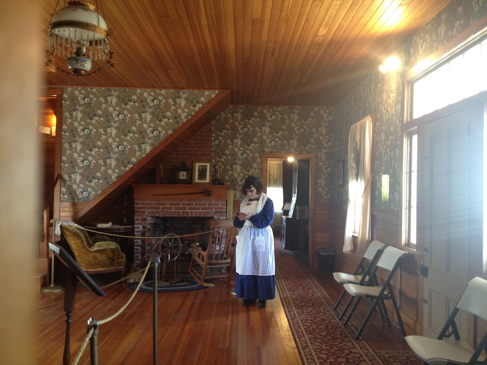
Newell House

Inside the Robert Newell House
The house was restored in 1952 by the Daughters of the American Revolution (DAR). The tour of the house is fascinating and gowns worn by the wives of Oregon’s Governors are displayed upstairs. There is also a display of Native American handcrafts and historical photos and news articles about the Newell as well as quilts, spinning equipment, and looms. There's lots to see.


There are a couple of other historical structures next to the Newell house museum, including the relocated Butteville jail (1848) and two-room schoolhouse (1859). These structures were relocated by the DAR in the late 1950s. You can continue riding from the Champoeg townsite to Butteville along the Champoeg bike trail, which parallels the Willamette River.


There are four miles of trails within the park. If you decide to ride to Butteville, you can see the historic Butteville store, which is more than 149 years old and the longest continually active store in Oregon.


Butteville is one of Oregon's earliest towns and was used as a river landing. It was an arch rival to Champoeg competing for shipping services needed by French Prairie farmers. It survived the devastating flood of 1861. West of the store is a mid-19th century mansion built by a prosperous grain merchant. The main traffic was by steamer in those times, so the front door faces the river. A ferry operated from Butteville in 1853. It was a thriving port until the railroad arrived.

From "A History of Oregon Ferries since 1826"
There's so much to see and so much history in this area, it's a great way to spend a day. There is also nearby St. Paul, which I'll cover in a separate post.