Showing posts with label history. Show all posts

12/27/2019

Fruit Lands and Turkey Town: Exploring Sutherlin and Oakland, Oregon

We've driven past the Sutherlin exit on Interstate 5 many times. Usually, we make a regular stop to eat at Romulos Mexican Grill (highly recommended!), but a brief look into the history of the area made me want to explore more and drive further in see to historic downtown Sutherlin.  


Sutherlin, once known as "Camas Swale," was organized into a town site from a large ranch inherited by Anne Sutherlin Waite from her pioneer father, Fendel Sutherlin (1824-1901). Anne and her husband, Frank Waite, decided to sell off the land as small farms. The camas wetlands throughout the area, drained by Fendel Sutherlin, were laid out into orchard tracts (mostly apples) between five and twenty acres in size by the Luse Land and Development Company (Frank Waite and J.F. Luse). The idea was to sell the tracts to home seekers in the mid-western and northeastern states with a contract requiring homeowners to maintain the orchards for several years. A post office was established, and the town was incorporated in 1911. Frank Waite built a small hotel, and a train depot site was donated to the Southern Pacific Railroad. Streets were laid out, a business district was built, homes were erected and the population was reported to be 800 by 1915 (The News-Review, Roseburg, Oregon, March 10, 1915).


Pioneer Life of Fendel Sutherlin by Anne Sutherlin Waite, Oregon Historical Quarterly
Vol. 31, No. 4 (Dec., 1930)
Many of the buyers, believing their property would produce a profit within five years, sold after the orchards were not yet at a level of production to make money. Other property owners were found to have torn out the orchards for more profitable crops or animals. Some, however, retained their properties and were rewarded with a fruit industry that grew to a level requiring the construction of two large packing plants and a fruit spray manufacturing plant. A box factory was constructed to supply fruit boxes for the growers, and the Sutherlin Lumber Company was formed. The town became known as the "Orchard Center of Douglas County." However, the financial return on the produce was low due to the high costs of shipping the fruit to major markets in the east. The last packing plant shut down in 1928 as the Great Depression began.

Sutherlin, Oregon in 1911 from "Sutherlin" by Tricia Dias
The Coos Bay Times (Marshfield, Oregon) · 1 Feb 1916
Above the valley, immense stands of timber were controlled by the Roach Timber Company. The owner, William Leroy Roach, made arrangements to construct a railroad line through the valley and up to the timber and logging camps. This enabled the transfer of timber from the logging camps into Sutherlin, where it was then transferred to the Southern Pacific Railroad's main railroad line. There were plans to build a large sawmill in Sutherlin; however, in August 1916 William Roach passed away from pneumonia, and the mill never materialized. The railroad line closed in 1961 after Weyerhaeuser purchased a mill to the north near Cottage Grove. The new mill purchase included a truck road, and it was decided that operations would be moved to the holdings northeast of Springfield.

       William Roach (Lumber World Review - July 10, 1916)

Weyerhaeuser #100

The town experienced a lumber boom in the 1940s. Other sawmills were constructed in Sutherlin, several of which were located at the present location of Murphy Plywood on Central Avenue. A few of the more long-term mills in operation include the L&H Lumber Company (1946-74); Springfield Plywood Corporation (1942-64); Nordic Plywood Corporation (1954-75); Mt Mazama Plywood Company (1975-85); and Murphy Plywood Company (Larry Moulton 2002).

The timber industry declined in Oregon during the 1980s from depletion of forest resources and new environmental restrictions creating the worst recession the state had experienced.  It was no exception in Sutherlin. The Mt. Mazama Plywood Company filed for bankruptcy in the mid-1980s ending employment for 185 workers. Murphy Plywood opened following the Mt. Mazama closure, but was  forced to shut down twice within one year due to poor market conditions. Unlike the more well-known destination, Bend, Oregon which capitalized on its scenic beauty and was successful in attracting companies in the aviation industry, Sutherlin was, unfortunately, not able to rebound from the lumber industry downturn.

Corvallis Gazette-Times - 25 Sep 1984

Today, Sutherlin remains an economically depressed town. I have to be frank - in my view, there is really no reason to visit at the present time.  There is no trace of the former orchard tracts, which have since been razed and devoured by rusting single-wide trailers and "canned ham" campers with a backdrop of heavily timbered hillsides. The downtown area is dilapidated with boarded windows and dingy storefronts. The one tourist feature of the town is the Weyerhaeuser #100 locomotive, retired in 1958, used to haul logs on the Roach Timber Company's railroad line. There is a plaque in front that says nothing about the train or the town's history. It is my personal opinion that Douglas County's economic revitalization lies, in large part, on its history, preservation of its forests, and restoration of its once glorious camas wetlands. One of the oldest stands of old growth timber in the world is found in Douglas County.

Downtown 1927
D.W. Banker Building (1916) and Sutherlin Bank Building (1910) on the corner of Central and State Streets. Then bank closed in 1933 due to poor economic conditions and reopened 1949-1973

A somewhat more interesting and well maintained historic town lies just five minutes north of Sutherlin. The town of Oakland, Oregon was founded by Dr. Dorsey S. Baker who constructed one of the state's first flour mills (1851). The mill wheel from Baker's grist mill is on display at the city park at the northeast corner of Second and Maple Streets.


Oakland was also a former stage coach stop on the route from California to Portland. The original town site during the stage coach years was actually one mile north of the present location. The town was moved to its present location in 1872 when the townspeople learned that the new railroad line would bypass Oakland. Some of the buildings were dismantled and rebuilt at the present location. The official stop for the stage coach was at the Pacific Hotel owned by Jonathan Tibbetts. Unfortunately, this hotel was not relocated and no longer exists. Other early establishments relocated from the original town site include the Deardorff Hotel (1860) at 337 NE First Street, the James Dearling House (1855) at 207 SE Second Street (originally a saloon in the old townsite), and James Dearling Cobbler Shop (pre-1871) at 226 Locust Street. Several additional residences were also relocated some of which include:


237 SE Second Street (c. late 1860s):


236 SE Second Street (c. 1865):


210 SE Second Street (pre-1871):
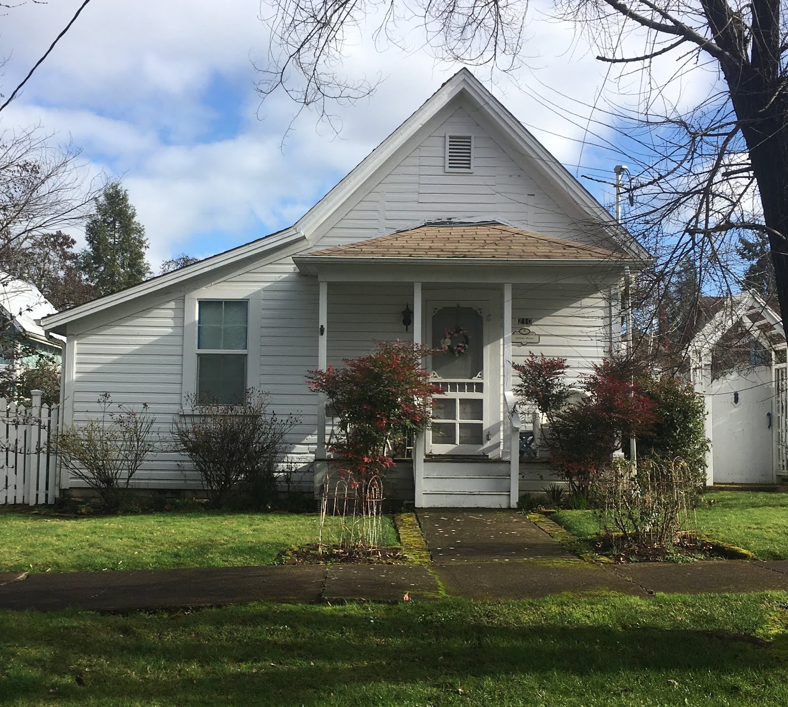


333 NE First Street (1850s):


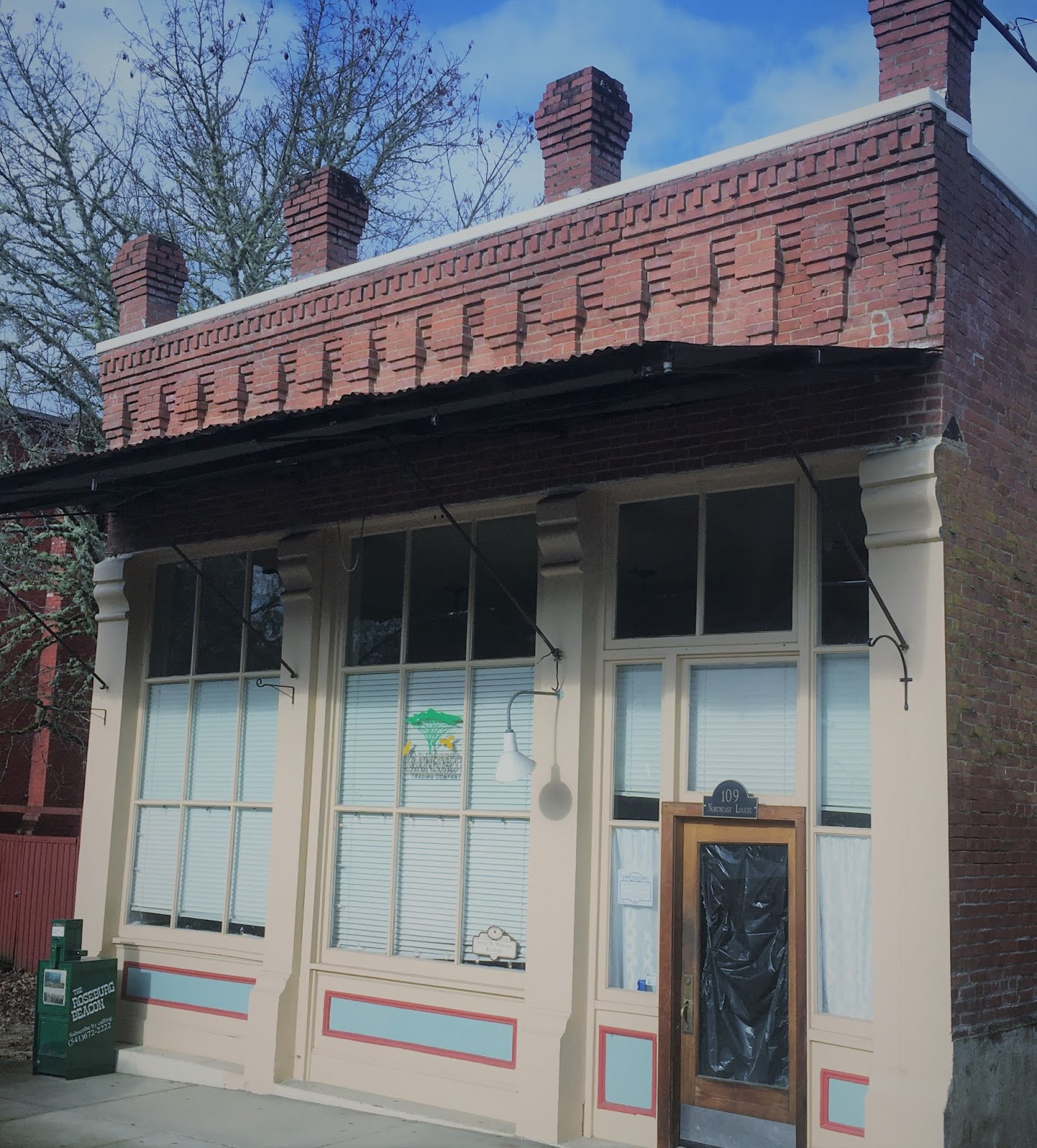
After the relocation of the town to its present site, Oakland became an important railroad shipping point for the surrounding area. The railroad stimulated construction, although two fires in the mid-1870s and 1890s destroyed many of the original wooden structures. Many burned establishments, such as the Depot Hotel (1899) at 101 Locust Street, and J.H. Mahoney saloon building (1899) at 109 Locust Street, were replaced with brick buildings.

Thomas Hotel building (1899), originally the Depot Hotel

Harvey J Mahoney building (1899), a former saloon


Both buildings can be seen on Locust Street on the 1889 Sanborn Fire Insurance Map.


By 1922 the population of Oakland grew to about 700. The town became known as the center of the turkey industry for the north Pacific Coast. In addition to turkeys, Oakland was known for its stock raising industry including sheep, hogs and cattle. Unlike Sutherlin, the consistent farming industry allowed Oakland to weather economic fluctuations. By 1929, Oakland ranked sixth in the nation in turkey production, although breeding began to decline in the mid-1940s.


The News-Review - Roseburg, Oregon 27 Feb 1961
During WWII, Oakland also benefited from the lumber boom. The city expanded to twice its original size. Oakland's chief contribution to the lumber boom was through its being the headquarters site in Douglas County for the Martin Bros. Box Company which opened in 1946. It manufactured wirebound shipping containers, lumber and plywood. 

Another industry stimulating growth included quicksilver mining. The original deposits were discovered in 1870 and abandoned after small production; however, the Bonanza mine was reopened in 1937 by H.C. Wilmot who organized Bonanza Mines, Inc. After reopening, production was low until the main (north) ore body was discovered in 1939. By 1940, the mine led all mercury producing mines in the United States. Some of the ore ran as high as 120 pounds of mercury to the ton, but it averaged only 7 or 8 pounds (USGS 1947, Quicksilver Deposits of the Bonanza-Nonpareil District, Douglas County, Oregon Bulletin 955-F). The mine was located about six miles east of Sutherlin and operated until 1961 with other closures prior to that time. Total recorded mercury production was 39,540 flasks (or 3,005,040 pounds).

Environmental investigations completed in the late 1990s show that soil and sediment at the former mine are contaminated by mercury, arsenic, and other metals. Cleanup of the site began in 2014.


3/06/2019

The Big Road: Oregon's Stagecoach Route

I was inspired by a book by Gary and Gloria Meier, called "Knights of the Whip," to seek out the remaining stagecoach stations on the old stage road known as the "Big Road." The Big Road was a route between Oregon and California used by native Americans, fur trappers, gold prospectors, military, and pioneers. It started as a pack trail and was developed into a wagon road by Jesse Applegate and others. It received appropriations in 1857 for improvements, as it was essential for military operations. Once it was improved to a condition in which heavy wagons could pass with less difficulty, the earliest commercial stage lines were established. On September 15, 1860, the California Stage Company made its inaugural run between Sacramento, California and Portland, Oregon.

Stage stations provided services for the customers and held a reserve stock of stage horses. Most of the stations were privately owned and run by pioneer families, on their Donation Land Claim properties, who contracted with the stage company and got reimbursed for their services. Starting on the Oregon-California border, we tracked down the southern Oregon stations:

Route between Cole's and Barron's Stations in Southern Oregon
The last stage stop in California before going over the Siskiyou Mountains into Oregon (and the first we visited heading north) was Cole's Station. Cole's Station is still standing and can be seen by taking Exit 796 on Interstate 5. Travel west on Hilt Road and take a right in the town of Hilt to stay on Hilt Road. The road runs to the northwest parallel to the railroad tracks and turns into Colestine Road. Cole's Station is one mile up Hilt Road on the right. The stage barn is visible on the left across the road. Cole's was established by Rufus Cole who headed west from Putnam County, New York in 1851 with his brother Byron to search for gold. Both homesteaded ranches in the Colestin Valley under the Donation Land Claim Act of 1850. Rufus built his home next to the Hudson's Bay Pack Trail which became a territorial road in 1855. He used his home at the first location as a stage station until he moved it south to the present location in 1859. The station served as a regular stagecoach stop for around 30 years.

Cole's Station in 1887

The above photo is from "Pioneers of the Colestin Valley"in Southern Oregon Heritage Today, November 1999, Vol. 1 No. 11. Today, the home is a private residence.

Cole's Station in 2019

Stage Barn at Cole's

The next stage stop in Oregon was Barron's Station, with nearby Casey's and Kingsbury's stations, both of which operated at times either when Barron did not contract for stage station services (Casey's) and for a short period after Barron closed his station in 1884 at the end of the stage days (Kingsbury's). Barron's was the first station on the Oregon side of the Siskiyou Mountains.

A biographical sketch of Major Hugh F. Barron was printed in The Oregon Sentinel on Wednesday, March 5, 1879. Major Barron lived with his wife, Martha, in a log cabin until he built a home on the same site in 1858. He acquired a second home, built by James Russell and James Gibbs, for his expanding cattle and sheep ranch. It was this home that became Barron's Station and was located about a quarter-mile north of his first farm house. The second house had already been used as a stage station, and Barron developed it into the "Mountain House" station where his wife was hostess.

The house, presently a private residence at 1148 Old Hwy 99 S, still stands today and can be seen by driving south on Highway 66 toward Emigrant Lake to the Old Siskiyou Highway. Turn right and the house is a quarter-mile on the right. The stage barn was formerly located across the road but no longer exists. In addition, Casey's and Kingsbury's stations no longer exist.

Barron's Station in 2019


The next few stations no longer exist, but we visited the old locations nonetheless:

Route between Barron's and Amerman's Station

Ashland Mills was not an official stage stop as it was only five miles from Amerman's. However, the stagecoach ran along what is now East Main Street, and many passengers stayed the night here. The earliest hotel was known as the "Ashland House," built in the year 1859 by Eber Emery at a cost of $3,000. Emery kept the hotel for 10 years and then sold to Abel Helman, and then to Jasper Houck. The hotel, located across from the I.O.O.F. Building, was demolished in the late 1910s. Images of the former hotel below are from the Southern Oregon Historical Society and from an Archaeological Survey of the Ashland Plaza conducted in 2013. The Ashland House was moved at least twice prior to its demolition. Once, a short distance at the Plaza, and a second time several blocks away to the Town’s Railroad District. Highway 99 and N Main Street now run through the former location.

Ashland House Hotel circa 1867 from "Ashland Plaza: Report on Findings of the 2012-2013 Sub-Surface Archaeological Survey of the Ashland Plaza Project Area Jackson County, Oregon" by Jeff LaLande

Ashland House Hotel in 1880s
Ashland Weekly Tidings - 28 Dec 1921


Amerman's Station was located the present location of 5595 Pacific Hwy, about one mile south of Phoenix, Oregon. Phoenix was known at that time as Gasburg. James Amerman was born around 1824 in Huron County, Ohio. It is believed that he may have come to Oregon in 1852 with his brother, Henry. Amerman purchased 320 acres of farm property from the original Donation Land Claim owner. He started offering stagecoach services in 1860 and passed away in 1871. His widow, Elizabeth, married William S. Stone, superintendent of the O & C Stage Company, on February 22, 1874 and the two kept the station operating. Oatman's Station was a mile north of Amerman's and also no longer exists.

Jacksonville was an important hub for the stagecoach in Southern Oregon. There were many structures dedicated to stagecoach operations, which were owned by the California Stage Company. Several hotels operated in Jacksonville, including the Union Hotel (later known as the United States Hotel) at California and 3rd Streets. The United States Hotel burned in 1873 and the Old Franco-American Hotel on Oregon and Main Streets, owned by Jeanne DeRoboam Holt became the official stop. Ms. Holt later purchased the burned United States Hotel and converted it into an elegant hotel which opened on November 19, 1880 and stands today. Unfortunately, the O&C Stage Company decided to make the official stop at the New State Hotel across the street from Ms. Holt's hotel. The Old Franco American Hotel burned in 1886.

From "Pictures in Time" by the Southern Oregon Historical Society
United States Hotel building in 2019
Route between Amerman's Station and Croxton's Station


The next stop north of Jacksonville was the community of Rock Point. The Rock Point community was founded by J.B. White in the early 1850s. J.B. fought in the Rogue Indian Wars, and in exchange for his service, he received land on which he developed a homestead on the south side of the Rogue River. A flood in 1861-1862 destroyed the bridge over the Rogue River and his home on the south side. He moved his home to the north side of the river and, in 1863, decided to open a store and sold the property to L.J. White (no relation). L.J. immediately began constructing a new bridge and stage station called the Rock Point Hotel in 1864.  On February 8, 1865, the hotel opened to the public with a grand ball. Lytte White died on October 28, 1878 and his sons and wife continued to run the stage stop at Rock Point. His son Henry bought out his mother and brothers and renovated the old hotel in 1887. But, by the turn of the century the hotel had closed and Henry had returned to farming. The building was purchased in 1907 by orchardist F. K. Deuel and others. It is the current site of Del Rio Vineyards and Winery.

Rock Point Hotel in 2019

Croxton's Station was 14 miles north of the Rock Point Station near 7th Street and Savage in current Grants Pass, Oregon. A newspaper article dated October 31, 1974 says the location was farther north, near Interstate 5 at about Vine and Highland Avenues. Thomas Frederick Croxton arrived in Illinois from Staffordshire, England in 1843 with his wife Hannah Box and seven children.  In 1849, he traveled to the west to try gold mining and was a traveling Methodist preacher before moving to Josephine County in 1857 to continue prospecting for gold. He acquired the property for the stage station in 1864 and began operating it with the help of his son-in-law, Ebenezer Dimmick. There was an earlier station just north of Grants Pass called Louse Creek Station, but the station was closed when the Big Road was re-routed to an easier grade over Merlin Hill (the present Interstate 5). After his wife died in 1866, Thomas Croxton became a pastor in Coos Bay, which was then known as Marshfield.  Ebenezer Dimmick continued operating the stage station until the end of the stage days. Nothing remains of the station, but Croxton's home is still standing (built 1866) at 1002 Northwest Washington Boulevard in Grants Pass. Croxton died in 1868.

Route from Grants Pass to Canyonville


The Grave Creek House was the next stop located 13 miles north of Croxton's. Formerly a region of conflict with the Native Cow Creek Umpqua tribe, James H. Twogood came to the site in 1851 to lay out his Donation Land Claim. He called the land “Grave Creek Ranch,” in memory of pioneers who perished there traveling north to Portland in 1846. Oregon Legislature passed an act renaming Grave Creek to Leland Creek in January 1854. By 1855, Twogood and McDonough Harkness acquired a former rest house (Grave Creek House #1 / 1854) for Applegate Trail travelers along Grave Creek, built a hotel, and contracted with the O&C Stage Company as a stage stop in 1860. A new hotel known as the Grave House #2 (1860) operated until it burned down in 1875. Then, a nearby farmhouse was enlarged enough to accommodate the stage company and was known as the Grave Creek House #3 (1876) or Harkness Inn. The Hugo Neighborhood Association provides a brochure with details on the station. The Grave Creek House stood just to the east of what is the old Pacific Highway (US-99) and north of today’s Grave Creek covered bridge. The Grave Creek covered bridge still stands and is off Interstate 5, Exit 71 with a marker providing history on the Grave Creek ranch.

Location of former Grave Creek House

Grave Creek House (later, Leland Creek House) from Josephine County Historical Society/Larry McLane

Wolf Creek Tavern was not an official stagecoach stop, but the roadside inn was used by other travelers en route to Southern Oregon and California.The hotel was the stopping place of President Hayes on his first trip to Oregon. According to a 1948 article in The News-Review and other sources, it is claimed that Ulysses Grant, Clark Gable, John Wayne, Jack London and author Sinclair Lewis stayed at the lodge, and one of the first three lodges of the I.O.O.F. was reportedly organized in its attic. The stage stop still operates as a restaurant and is listed on the National Register of Historic Places.

Wolf Creek Tavern in 2018
Dining Area at Wolf Creek Tavern

Established by pioneer Daniel Levens, the Levens Station was situated 13 miles north of Grave Creek and was a home station for drivers. Mr. Levens was active in other businesses including a store, hotel and grist mill in Canyonville. Levens re-built his original stage house in 1880 with a larger and more elaborate structure. Fred Tice drove the stage in 1878 and 1880 from Rock Point to Levens Station, a 45 mile drive on the old stage route. Tice lost a six-horse team by spring flood waters in Cow Creek on March 4, 1879 during the night (Medford Mail Tribune, 1 Sep 1931). There were few bridges at that time and fording was common. The Levens Station burned to the ground in 1931 according to The News-Review, 16 Mar 1932.


The Overland Hotel, formerly known as the Canyonville Hotel, was located on the corner of what was once Washington and 1st Streets (now 5th and Main) in Canyonville, Oregon. The hotel was built in the 1860s by John Arzner and George Wagner. It was originally constructed for a lodge room and store and was later used as a hotel because the emigrant stage travel became so heavy that another hotel was needed. It was run by David McCallen and his wife Electa between 1865 and 1867, and by William and Christina Spicer in the 1870s. William Spicer died in 1876 and his wife continued to run the stage stop until it was purchased by William Briggs in 1886. The Briggs family kept the property which was converted back into a grocery store until it was partially torn down in the 1950s.

The News-Review, Roseburg, Oregon, 25 Nov 1940

We traveled as far as Canyonville but will save the rest of the route north to Portland for another time!

3/08/2018

Taverns in Historical Buildings -- Southern Oregon

While the first Euro-American settlers came to southern Oregon as trappers, urban development in Southern Oregon was initially driven by the California Gold Rush. Many Oregon prospectors streamed to the area from the Willamette Valley in 1848-1849 after word of a gold strike at Sutter's Mill spread throughout the country. Additional discoveries in the Illinois Valley (known as "Sailor's Diggings"), Waldo, Rich Gulch, and Althouse established the importance of the area as a gold mining region. A small mining camp at the head of the confluence of Jackson and Daisy Creeks quickly developed into the town of Jacksonville, and the town was named the county seat in 1852.

There's a lot of history to explore in the Rogue River Valley, and having a solid list of pubs while visiting the area is essential. What's even better is visiting an establishment that is situated in a historical landmark. We've scoured the area for some the best pubs in historical buildings to try.

1. Homestead Pub & Restaurant (119 E Main Street in Rogue River). Originally named Woodville, the town of Rogue River began with a river crossing, known as Evans Ferry, along the California-Oregon Trail. The ferry was set up during the gold rush days of the 1850s. When Mark Whipple opened the Homestead Tavern in 1906, he had a booming business until Prohibition was enacted in 1914. The tavern was converted into a grocery store, cafe and real estate office until 1933 when Prohibition was repealed. Ward Wills, who ran the cafe, converted the market back into a pool hall and bar and named the entire complex the "Homestead" in 1935.

Historical Image from "Rogue River" By Cheryl Martin Sund

The Homestead Pub still has the large neon "H" sign that was added in the 1960s.  Currently the Homestead bills itself as a pub AND restaurant even though it still appears to be more the former than the later. The bar has live music weekly with shuffleboard and pool tables. The menu was standard pub fare, burgers, sandwiches (with excellent French fries), but slim pickins' for vegetarians with only one option.  There is full bar with about 8 beer taps that are dominated by Bud-Miller-Coors monopoly however they do offer a couple good local craft beers.  The friendly clientele is what you would expect from any Southern Oregon dive bar, gravelly-voiced eye-patch-wearing grandmas rubbing elbows with local pot farmers.


2. J'ville Tavern (125 W California Street, Jacksonville). Built in 1856, the J'ville Tavern at 125 W California St, Jacksonville was originally a general merchandise store named Anderson & Glenn General Merchandise. One of the first merchants to sell supplies to the area's gold seekers, John Anderson established his business in this small, rectangular fireproof brick building. The store survived two of Jacksonville's major fires in 1874 and 1884. Anderson joined in partnership with James Glenn, large landowner and town treasurer, in 1859. The men continued to operate a dry goods store here until 1866 or 1867, when the business became Glenn, Drum and Co. In the 1870s, the business operated as Martin and Drum, and then as White and Martin. However, John Anderson maintained ownership of the building until 1877 when it was sold by his widow to Louis Solomon. It was used continuously as a merchandise store until the turn of the century.

Bird's Eye View of Jacksonville 1883 from the Library of Congress

While several businesses have operated here, the J'ville Tavern is currently occupying the building.


Inside, the J-ville Tavern has a full bar, friendly staff and a very respectable tap line-up.  This is not really a place to get food, just more of a watering hole to escape the scorching summer heat or to rehydrate after a day of hiking/biking the surrounding hills.  Hundreds (thousands?) of dollar bills have been pinned to the ceiling by various customers.  The bills are apparently harvested once per year with the money going to a local charity.  Pretty cool. 


3. Grape Street Bar & Grill (31 S Grape Street, Medford). 
In the early 20th century this site on Grape Street (29 and 31 Grape St.) was occupied by a large building used as a livery stable with a blacksmith shop. The Grape Street Bar & Grill building, formerly known as the Davis Storage Warehouse, was most likely was constructed in 1921 after a fire in the old West Side Feed & Sale Stable next door. After construction, the Davis Transfer and Storage Company operated a moving and shipping business here and in the adjacent stable building until the mid-1930s. During WWII, the buildings operated as the City Transfer Company. These two companies (Davis and City Transfer) were among the three or four transfer businesses that existed in Medford at that time. Orchards and ranches relied heavily on them to transport their produce and supplies to and from the railroad freight depot. The building was eventually sold and used as an automobile garage from the mid-1950s through late 1970s. It still has an industrial look with large multi-pane windows and central bay.

The West Side Feed & Sale Stable Building next door at 29 Grape Street in 1909 (National Park Service)
Building front as it looks today with the West Side Feed & Sale Stable Building next door

Interior with exposed brick walls
Today the newly opened Grape Street Bar and Grill occupies the space in addition to a nice patio out-back.  This is a great place to grab a pint and a bite to eat.  Grape Street has a full bar with about 20 really good (mostly Oregon and California) micro brew taps.  The Happy Hour specials here are the best around with dollar off drinks and two dollars off appetizers.  The garlic fries are pretty awesome.  There is live music on the weekends and Tuesdays.  The Tuesday sessions alternate between either blues or jazz.


4. Climate City Brewery (509 SW G Street, Grants Pass). 
The original use for the Climate City Brewery building was.... a brewery! The Grants Pass Brewery was first established at this location in 1887 by William Neurath who built it near his well adjacent to Gilbert Creek. Neurath sold the brewery’s rights to Eugene and Marie Kienlen in 1891 who emigrated from Minnesota. The original building was wooden, which was destroyed in the 1902 fire along with many other buildings on G Street. Kienlen rebuilt the brewery with fireproof brick. Kienlen transferred the property to his wife in 1904 after he learned of a serious illness which took his life that same year. Marie held the business until 1908, when Grants Pass passed a local prohibition ordinance. The business subsequently closed down. Other businesses operated here including a saddle and harness store, a granary, grocery store, warehouse, art gallery, and restaurant.

Grants Pass Brewery Historical photo from "Grants Pass" by Joan Momsen and Oregon Brew Lab
1890 Sanborn Map depicting Grants Pass Brewery

Today, you can still dine and drink some locally brewed craft beer on a comfortable patio situated next to Gilbert Creek. If you choose to stay inside, you'll enjoy dining in a rustic atmosphere with tall ceilings, exposed duct work, wood beams, and exposed brick walls.


Acacia Cooper started as brewmaster at Climate City in May 2016. There is an extensive list of house beers available currently including (as of this writing):

Rainie Falls Red ABV 5.5%, IBU 50
Bigfoot Bourbon Porter ABV 6.6%, IBU 32
Fireside Dark Ale ABV 6.8%, IBU 37
Citrodora Strong Ale ABV 6.9%, IBU 37
Hyperion Porter ABV 6.5%, IBU 32
Hot Shot Smoked Helles ABV 5.1%, IBU 28
Winter Wonderbier  ABV 7.6%, IBU 20
Takilma Kolsch  ABV 5.0%, IBU 28
Nookie IPA  AVB 7.2%, IBU 80
"No Stout About It" Stout  ABV 5.6%, IBU 26
Savage IPA  ABV 7.0%, IBU 90
River Town Brown ABV 5.0%, IBU 20
Maracuya Gose ABV 4.5%, IBU 18
Ray's Imperial Red ABV 7.2%, IBU 53
Powerhouse 100 Double IPA ABV 8.2%, IBU 100
Roguator Dopplebock ABV 7.0%, IBU 33
Yellowbelly Blonde ABV 5.4%, IBU 21
French Roast Coffee Stout ABV 5.6%, IBU 26

Happy Hour food is served Tuesday-Friday from 3pm-6pm.  On weekdays Climate City has one of the best lunch specials around:  ten bucks for a burger, fries and a pint!

5. Omer's Restaurant (1380 Siskiyou Blvd, Ashland). 
Located near the Southern Oregon University campus, Omer's Restaurant is part of Ashland's history as its oldest restaurant and first public cocktail lounge. The restaurant, opened in 1946 by Omer and Hazel Hill, was built by the owners themselves. They planned to call it "Omer's" but the sign painter incorrectly spelled it as "Omar's."

When you step inside it's like stepping back in time. The booths and Formica tables may even be original. While the restaurant has changed hands, the restaurant's website provides some background on the original owners.


According to a Jefferson Public Radio story, Ashland’s mayor encouraged Omer to open a cocktail lounge in the 1950s because the Elks Club and a few other places served only beer and wine and shut down early. The vintage signs are still in use and the building hasn't changed much since then.