8/05/2014

Rafting the McKenzie River

Rafting on the McKenzie River, Oregon: From its headwaters in Clear Lake, the McKenzie River flows southward through the Cascades of Linn County, Oregon, and bends west through Lane County eventually converging with Willamette River five miles north of Eugene, Oregon.


Submerged 100 feet deep in Clear Lake is a stand of upright trees that were killed approximately 3,000 years ago when volcanic activity created the lake. Clear Lake is fed from snowmelt that filters underground for over two decades before emptying into it. Just below Clear Lake are two notable falls that are accessible from the 2.6 mile waterfall loop hiking trail: Sahalie and Koosah Falls. The simple map below shows the location of the falls and course of the McKenzie River in Linn County just above Olallie Campground.


On day one, we put in at Olallie Campground and floated through the National Wild and Scenic River Corridor to Paradise Campground. This 9 mile section is said to be the most pristine, scenic, and exciting stretch of the river with continuous rapids including Fishladder Rapids (Class III), the most difficult on the section.The flow during our trip was around 2,500 cfs with water temperatures around 55 degrees Fahrenheit. Day two was from Paradise Campground to Hamlin Boat Launch. The map below shows some of the rapids and river access points. Corrections are appreciated.


The second day was mainly class II rapids with plenty of opportunities to take photos of Jeff and Marie navigating the rapids and rock gardens.

Photo McKenzie River Rapids

The flows in the McKenzie are fairly continuous from Olallie Campground. The waters are clear and cold, and the river is fed by a number of tributaries including the South Fork, which connects to the McKenzie about 8 miles below McKenzie Bridge community; Lost Creek, which joins the McKenzie just below Belkap Springs; and the Blue River (named for the color of rocks in its bed), which joins the McKenzie about 11 miles south of McKenzie Bridge. The entire river drops 3,000 in elevation before converging with the Willamette.


The McKenzie River supports spring Chinook salmon, winter steelhead and summer steelhead as well as native rainbow, cutthroat and bull trout. The high lakes have been planted with brown and brook trout. Along the stretch from Paradise Campground you will come to the Goodpasture Bridge, which is a covered bridge near the community of Vida. It is the second longest covered bridge in the state.


The river flow has been diminished by the Cougar and Blue River dams. After dam completion in 1968 average annual river flows were only 60 percent of the average annual peak flows that occurred before dam construction. Before the dams, a high flow of 31,000 cfs occurred every three years; since the two dams were built, the 31,000 cfs flow has an expected 100-year recurrence interval (McKenzie River Subbasin Assessment Summary Report, February 2000).


The clear, cold water was ideal for a mid-August weekend. The McKenzie is certainly one of Oregon's premier rivers with its crystal clear water banked by lush forests, and I feel fortunate to have had the opportunity to experience this gorgeous area by boat.

7/17/2014

Oregon MTB 24 HR Bike Race - Bend, Oregon

2014 Oregon 24 Hour Mountain Bike Race Photos - Bend, Oregon: The mountain bike trails and conditions challenged riders at the 2014 Oregon MTB 24 HR Bike Race held by Mudslinger Events in Bend, Oregon. With temperatures well into the 90s and powdery Central Oregon soils suspended in the stagnant, hot, dry air, the riders were choking on dust and melting in the heat as they repeatedly wound their way around the 10.58 mile loop. Despite the miserable conditions, the race was well managed with plenty of amenities and monitoring. The misery began at 11:00 am on Saturday, July 12 with a 200 yard running start. The riders were looking very fresh (and dust free) at that point!

Oregon 24 hour mountain bike race running start

But, it didn't take long for things to get stirred up, and the riders were contending with fine dust choking their lungs within the first lap. These riders were just finishing lap #1 with  more dust and heat to come.

Oregon 24 hour mountain bike race first lap

Covering mainly single track mountain bike trails with some forest road sections, the course began off Cascade Lakes Highway. It was a 10.58 mile loop with an elevation gain of 1,014 ft as described on the official race web site. The Garmin race profile shows the elevation change throughout the course, which ranged between 5,382 to 5,758 feet.


After the final climb at mile 8, the riders rounded a corner and headed into a wide, fast downhill section with ample opportunities to overtake unsuspecting opponents.

Oregon 24 hour mountain bike race downhill

Solo rider, Jeff Sanders, took advantage of the fast descent.


The relief from the downhill sections was short-lived, however, and before they knew it, the riders were back into the grueling uphill sections with little shade and the full force of the sun causing their heads to throb.

Oregon 24 hour mountain bike race rider Jeff Sanders

Dusk provided some level of "relief" with temperatures abating. However, even at dusk the riders still had 14 hours of riding ahead of them. The race went on, loop after loop, throughout the night. By morning, everyone was red-eyed and caked with dust. The race results are provided on the official web site. Jason Perez of Brentwood (Solo Open Singlespeed) completed an impressive 19 laps with Sean Evans of Calgary, Alberta Canada (Solo Master Men 40-49) finishing 17 laps. Good job to all of the riders. As a spectator, the hot and dusty conditions were miserable, so I can only imagine the strong will it took everyone to keep going. Great work!

7/06/2014

Mount St. Helens Volcanic National Monument - Skamania County, Washington

Mount St. Helens Volcanic National Monument 

Skamania County, Washington

I had been wanting to visit Mount St. Helens for a long time. I think I was in sixth grade when it erupted. I can remember talking about it in the classroom and staring with awe at a canister of ash sent back to my Midwestern town from a classmate who had moved to Oregon. The volcano stands at 8,366 feet in elevation and blew its top off at 8:32 am on May 18, 1980. The USGS has a great short film on the eruption and some of the scientists describe their experiences seeing the blast over 34 years ago.


According to the U.S. Department of Agriculture, nearly 150 square miles of forest were obliterated (230 square miles according to the USGS video above). We started our tour of the area at the Mount St. Helens Science and Learning Center overlooking Coldwater Lake. The facility has an excellent balcony overlooking the lake and volcano.

Mount St. Helens Coldwater Lake

We left the Learning Center and drove to the Johnson Ridge Observatory, which is the location of the Boundary Trail #1 trailhead. Our plan was to hike Boundary Trail and take Truman Trail #207, which leads you inside the blast zone across the Pumice Plain towards the base of the volcano. You will need a day pass, which can be purchased inside the Mount St. Helens Learning Center or Observatory for $8. As you begin the hike, you'll see that although life is returning to the area, it is a slow process (from a human perspective).

Mount St. Helens recovery

Mount St. Helens forest succession

In order to reach the Truman Trail #207, you will need to hike east along Boundary Trail #1 for 2.3 miles. At the turnoff, the Truman Trail will first lead you south along a ridge with spectacular views of the crater, then will drop down into the pumice plain. From Truman Trail, there is a clear view of the lava dome inside the crater, which has been transformed many times since the eruption. New domes have continued to grow and collapse over time.

Mount St. Helens Truman Trail view

The USGS provides a great time lapse video of dome growth between 2004 and 2008.


Eventually, trail #207 drops down into the pumice plain where there is a great view of Spirit Lake and Mount Adams. If you continue on, the trail winds around Spirit Lake for about 7 miles and will lead you to Windy Ridge Viewpoint.

Mount St. Helens Spirit Lake view

Three and a half miles after the turn-off onto Truman Trail, you will come to several branches off the main trail, many of which head south towards the base of the volcano. The USDA has a detailed trail map at the visitor centers, and there is a less detailed version available online. Trail #207A or #216 will lead to Loowitt Falls at the base of the volcano. We followed Truman Trail #207 for probably about 3 miles before turning around.

Mount St. Helens pumice plain

We only scratched the surface of the trail system in the national monument. If you choose not to turn off Boundary Trail, it will lead you north to St. Helens Lake and several campsites. There are also lectures, films, and guided hikes offered by Forest Service staff.

6/15/2014

Northern California: Shasta, Trinity, and Siskiyou Counties

Historic Tour through Gold Mining Country, Northern California: We recently took a week to explore some of the historical sites and wilderness areas within Shasta, Trinity, and Siskiyou Counties of northern California. This part of the State has a fascinating history of gold mining, trapping, and logging that I thought of as we crossed over the same mountains and rivers that the Forty-niners traversed on their way to the gold fields. We didn't have a lot of time, but started our trip by following the Trinity River via Highway 299 to Weaverville. This highway frequently follows the old Trinity Trail, which was opened up by trappers and gold miners in the 1830s. Jedediah Strong Smith and his party were probably the first white men to explore the area in 1828. In the 1840s the Trinity River was named by Major Pierson B. Reading, thinking it flowed into Trinidad Bay on the Pacific Coast. Actually, it converges with the Klamath River in Northern Humboldt County.

Trinity River
According to the Daily Alta California, Volume 22, Number 7416, 11 July 1870, a gold nugget weighing eight pounds was found by George Van Matre, near Minersville, Trinity County. Another weighing eleven pounds was found about the same time by J. W. Smiley, near McGillwray, in the same county. Minersville in Trinity County was an area of rich pocket mines.

We continued on Highway 299 heading east towards Weaverville. The map below shows our route and the location of Trinity County in the State of California.


Weaverville is the Trinity County Seat with a population of around 3,600. It is a well-known historic gold rush town that burned down many times since its establishment. Weaverville was home to aound 2,000 Chinese gold miners. The town even had its own Chinatown. The oldest continuously used Chinese temple in California (the Joss House) is located in Weaverville and is now a State Historic Park. It happened to be closed the day we were there.

Joss house Weaverville California
Joss House
Weaverville was named in 1850 for gold prospector, John Weaver. In 1853, a fire destroyed the town for the first time. Thirty-five of the 41 buildings burned down. The residents replaced many of the town's wooden and canvas structures with brick. Another fire destroyed the town in 1855 and more brick buildings were added. Heavy iron doors and shutters were added as protection from frequent forest fires. The Pacific Brewery built by Frederick Walter is one example. The brick portion of the building dates to 1854.

Fire Weaverville California history
The old Pacific Brewery
Nineteen brick buildings erected between 1855 and 1859 are still in use today. The courthouse was built in 1856 as a saloon, store, and office building. It has been in use as the courthouse since 1865. The adjacent bandstand was built in 1901.

Weaverville California courthouse and bandstand
Court house and Bandstand
A couple of two-story brick buildings on Main Street have spiral staircases. Since each floor of these buildings had separate owners, the staircases were were built to provide access to the second floor owners. Space inside the buildings was limited, so iron staircases were constructed on the outside. Clifford Hall and the Buck and Cole General Store are examples of buildings with these spiral staircases. The oldest staircase was built in 1860 and the newest in 1935. The Buck and Cole general store sold groceries for over 100 years. The Clifford building is at least the fourth building on the site; fires destroyed at least two of the previous structures.

Weaverville California spiral staircases
The Old Buck and Cole General Store with Spiral Staircase
The FW Blake Bank was built in 1856 and served as the headquarters for the Trinity National Forest from 1909 to 1934. Today it's "The Diggins," a local bar.... and yes, of course, we have photos of the inside.

Weaverville California Tavern
The Old F.W. Blake Bank
Weaverville California The Diggin's
The Diggin's
For me, one of the most interesting sites in Weaverville was at the Jake Jackson Memorial Museum. The museum had two floors of historical photos and materials cataloging the history of Trinity County in addition to several outdoor exhibits. The outdoor exhibits included a LaGrange Mine ditch tender's cabin, restored barn, blacksmith shop, and the only working steam stamp mill on the west coast. Stamp mills were mechanical crushers that allowed miners to extract metals from the ore.

Weaverville California ditch tender's cabin museum exhibit
Inside the ditch tender's cabin
Stamp mill weaverville california
Stamp Mill Cart
Visiting Weaverville is not only about the historical sites in town. It is surrounded by the Trinity Alps Wilderness which is the second largest wilderness area in California. The town is also well known for its mountain biking trails. Adjacent subranges of the Trinity Alps include the Salmon Mountains and Scott Mountains.

Weaverville California camping
Exploring Forest Roads
Weaverville california nature butterflies
California Tortiseshell (ventral)
We left Weaverville and continued our journey heading east towards Whiskeytown and Redding, California. Just before the Whiskeytown Lake, we stopped at the Camden House and site of the former Tower House Hotel. Levi H. Tower and Charles Camden arrived at this spot in 1850. Tower built the 21-room Tower House Hotel with lumber hewn from the surrounding forests and split by hand. The Tower House Hotel no longer remains and was destroyed by fire in 1919. 

Tower House Hotel California
Tower House Hotel
Some time later, Charles Camden built his home near the hotel, which was considered a "showplace" of the county at the time. Charles Camden mined for gold in the area until 1866 and married Philena Tower, the sister of hotel owner, Levi Tower. In 1968, the State of California purchased the Camden house and property from the Camden heirs. Camden died in 1912 in Oakland.

Camden House California
Front room of the Camden House
Camden House California
Camden House kitchen
Camden House California
Camden House
We continued east through Whiskeytown (now flooded by the Whiskeytown Dam, which was built in 1962). An interesting fact is that the U.S. Post Office refused to allow the name Whiskeytown as a postal destination until 1952. Along the way, we stopped in the town of Shasta in Shasta County. This town is a State Historic Park and was originally called "Reading's Springs" by settlers who arrived there in 1849. It was a wagon transportation center for the Trinity mines and up to 100 freight teams stopped there on a single night. The town deteriorated after the decline of the mining industry and was abandoned through 1948. After this time, the property was purchased by McCloud Parlor No. 149 and presented to the State of California. It is the location of the first Masonic Lodge established in California. Today, the restored county courthouse is a museum. Shasta was originally the county seat, which was moved to Redding by 1888. 

Shasta California museum
Old Shasta County Courthouse, Shasta, California
Shasta California museum wagon team
Wagon team in Shasta
All that remains of the town is a series of brick storefronts. Destructive fires in 1852 prompted reconstruction with fireproof brick.

Shasta California store fronts
Remaining brick store fronts with fire proof iron doors
Historical Shasta California


I wanted to continue northeast to see the McArthur-Burney Falls located in McArthur-Burney Falls Memorial State Park. This was of interest to me because I had read that in 1843 the Chiles-Walker party of New Jersey, with Pierson Barton Reading (a prominent explorer at the time), followed an uncharted course along the Pit River through the mountains. Reading's notes read, "In some places the descent from the top of the bank to the water must have been 1,200 feet, the stream pitching over rocks and ledges, forming beautiful cascades, one of which had an abrupt fall of about 150 feet." This fall was McArthur-Burney Falls. The party experienced significant hardships on this journey. Reading wrote to his brother of the days of fatigue and suffering. The party avoided starvation only by eating the flesh of their horses and mules. How intriguing is that? Because we were only interested in staying at the park for about an hour to see the falls, we decided not to pay the $16 entry fee and see it another time. 

So, we ended up heading north and stopping in the towns of Mt. Shasta and Dunsmuir. Dunsmuir is an old railroad center, popular in the day when wagons and mule trains were replaced with freighters. The route of the Southern Pacific Railroad was nearly identical with the Oregon to California Trail and passed through Dunsmir. Although the station is gone, but when it was active, extra engines were added to northbound trains here to push the them over the summit.While there is a museum and old brick railroad hotel here, we only stopped for the night and headed north in the morning to the town of Dorris. We were able to check out a dramatic rock formation called Castle Crags, just south of Dunsmuir. The peaks were granite intrusions (plutons) eroded over time by glaciers.

Castle Crags California
Castle Crags
Mount Shasta California
Mt. Shasta
We passed through the town of Dorris, home of the country's "tallest flagpole" and another old Southern Pacific Railroad station. There wasn't much to be seen here, and the town was dilapidated. There are remains of an old train station that appeared to house a museum at one time. 

Dorris California museum
Former? Butte Valley Museum
Dorris California railroad
Railroad line through Dorris
We had one final campsite in California located west of highway 97 on Juanita Lake. There were a few obviously unused trails for mountain biking. We decided to try a ride up towards Ball Mountain. Large sections of the trail were washed out from what looked like a land slide or logging operations. The trail signpost towards the top was broken and lying in the brush. We took the wrong way and ended up riding a loop back to the main trail. It was a nice ride even if we got off the main path.

Juanita Lake Campground mountain bike
Ball Mountain Trail
Juanita lake California
Juanita Lake, Siskiyou County California
Our last leg of the trip included a brief tour of the Lower Klamath National Wildlife Refuge, the nation's first waterfowl refuge. Sadly, waterfowl on the Pacific Flyway are likely to suffer in the coming years due to an ongoing drought in California and southern Oregon. The Lower Refuge is expected to be dry by July 2014

Lower Klamath National Wildlife Refuge


5/16/2014

The Aurora Colony

The Aurora Colony - Aurora, Oregon: The town of Aurora, Oregon is located in the north central Willamette valley, about 24 miles south of Portland. It was established by a small group of scouts from Bethel, Missouri ("Bethelites"), who left that area in 1853 to find a site in the Pacific Northwest to establish their German-speaking, Christian commune. The group eventually settled on a tract of about 500 acres just south of the Willamette River in Marion County, Oregon. The land was purchased and named Aurora after the leader, William Keil's (1812-1877), daughter. The colony eventually grew to around 600 colonists until William Keil died in 1877. After his death, communal activity ended and properties went to individual farmers.

While Dr. Wilhelm Keil's house no longer remains, several homes of the original colonists have been preserved. Some historical photos of the colony, including one of Keil's home can be found on the Oregon Encyclopedia's web site, and information and photos on the colony members are provided by the Old Aurora Colony Historical Museum. Today, over 30 original colony buildings survive including the home of Emma Wagner Giesy (1833-1916), wife of the scout leader Christian Geisy, and sole female on the first trip from Missouri:

Emma Wagner Giesy Home Aurora Oregon
Emma Wagner Giesy House
The George Kraus family also lived in this same house from 1881 to 1867. Author, Jane Kirkpatrick, has written a novel about Emma's journey with this group of settlers in "A Clearing in the Wild." It is historical fiction based on the life of colony members and their migration to the west.

John Hans Stauffer was also a member of the original scouting party and settled three miles south of Aurora, and the family farm still exists today just north of Hubbard, Oregon.

Other colonists who arrived later included Christian Zimmerman (1838-1920), a carpenter. The Zimmerman House remains on the corner of Liberty and 3rd Streets in Aurora. A 150 year old walnut tree still stands in front of the house:

Christian Zimmerman House
Anton Will (1871-1962) built a house for his wife, Anna, directly across from the Zimmermans:

Anton Will House
Henry Kraus (1845-1918) was a carpenter and storekeeper who built a home on Liberty Street:

Henry Kraus House
Across the street from the Henry Kraus House is the Leonard Will (1823-1906) house, the colony butcher. Leonard and his wife, Josephine, had 7 children:

Leonard Will House
According to the Old Aurora Colony Museum, the original colony was non-denominational. Lutherans and Presbyterians who arrived in the area later built a Presbyterian Church in 1911:

Aurora Presbyterian Church
Charles Snyder (1844-1924) was a settler from Ohio. He built a house on the corner of Liberty and 3rd Streets where he lived with his wife Christina Schuelle Snyder and their seven children:

Charles Snyder House

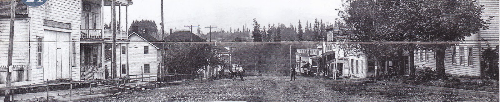
One historical image provided by the Aurora Colony Museum (below) shows Main Street in 1908. Several of the original buildings still stand today.


For comparison, a photo of Main Street taken in 2014:


In both photos, the WM Keil and Company Store stands distinctively on the left.....

Wm Keil and Company Store

next to the William Fry House:

William Fry House

William Fry (1835-1906), from Pennsylvania, was a blacksmith who settled in Aurora with his wife Annie and their four children.

Across the street was the Will-Snyder Store, built in 1912:

Will-Snyder Store

Other buildings that no longer exist include the Aurora Colony Drugstore, which was torn down in 1962 and Aurora Colony Store, which was torn down in 1931 to make room for Highway 99 East that now runs through the middle of town. At one time an impressive hotel also stood near the railroad tracks called the Aurora Pioneer Hotel (1867-1934). A historical photo of the hotel can be seen on the Canby Historical Society web page. The only surviving building from the hotel complex is an octagon building located off 2nd Street. The historical use of the building is unknown.

Aurora Pioneer Hotel Octagon Building

The home of Jacob Miley (1838-1907) stands near the railroad tracks behind the Walter Fry house. Jacob was a settler from Ohio and built this home in 1867:

Jacob Miley House

The Walter Fry (1882-1974) House still stands on Main Street:

Walter Fry House

The Southern Pacific Railroad Depot is currently just adjacent to Walter Fry's home. It was formerly located near the old mill and relocated in 1990. Aurora was an agricultural town known mainly for hops, dairy and filberts. The food was also acclaimed as known from an article in the Portland newspaper, The Oregonian, which praised the fried potatoes, pig sausage, smoked ham, bread, cottage cheese, candies, jellies, and cakes... (Sreenivasan, J, 2008). Visitors were greeted by the community band which played on the roof of the Aurora Pioneer Hotel.

Aurora Depot

The Aurora State Bank building came from the Lewis and Clark Centennial Exposition in Portland and was relocated to Aurora in 1905. Lyn Topinka provides postcard images of the exposition. The bank's two original vaults remain, but are now used by a local winery which uses the building for its tasting room:

Aurora State Bank Building

The colony warehouse, or Ziegler's Warehouse, still remains and is currently used as an architectural salvage business. The remains of a grist mill are located in 1st Street adjacent to the warehouse (no photo). It was built by David Smith who was born in Ohio and came to Oregon in 1851. The grist mill was built in 1853 and destroyed by fire. Another was built the same year. Smith sold it in 1856 and moved to Yamhill County.  

Ziegler's Warehouse

Jacob Miller (1837-1916) was one of the original colonists. His house was built in 1889 and is located across the street from the Aurora Colony Museum:

Jacob Miller House

Finally, the current location of The Old Aurora Colony Museum is in an old ox barn on 2nd and Liberty Streets. The building was later converted to a store, and then to the museum.

Old Aurora Colony Museum Oregon
Old Aurora Colony Museum

Museum Interior