Historic Tour through Gold Mining Country, Northern California: We recently took a week to explore some of the historical sites and wilderness areas within Shasta, Trinity, and Siskiyou Counties of northern California. This part of the State has a fascinating history of gold mining, trapping, and logging that I thought of as we crossed over the same mountains and rivers that the Forty-niners traversed on their way to the gold fields. We didn't have a lot of time, but started our trip by following the Trinity River via Highway 299 to Weaverville. This highway frequently follows the old Trinity Trail, which was opened up by trappers and gold miners in the 1830s. Jedediah Strong Smith and his party were probably the first white men to explore the area in 1828. In the 1840s the Trinity River was named by Major Pierson B. Reading, thinking it flowed into Trinidad Bay on the Pacific Coast. Actually, it converges with the Klamath River in Northern Humboldt County.
 |
| Trinity River |
According to the
Daily Alta California, Volume 22, Number 7416, 11 July 1870, a gold nugget weighing eight pounds was found by George Van Matre, near Minersville, Trinity County. Another weighing eleven pounds was found about the same time by J. W. Smiley, near McGillwray, in the same county. Minersville in Trinity County was an area of rich pocket mines.
We continued on Highway 299 heading east towards Weaverville. The map below shows our route and the location of Trinity County in the State of California.
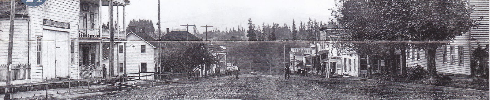
Weaverville is the Trinity County Seat with a population of around 3,600. It is a well-known historic gold rush town that burned down many times since its establishment. Weaverville was home to aound 2,000 Chinese gold miners. The town even had its own Chinatown. The oldest continuously used Chinese temple in California (
the Joss House) is located in Weaverville and is now a State Historic Park. It happened to be closed the day we were there.
 |
| Joss House |
Weaverville was named in 1850 for gold prospector, John Weaver. In 1853, a fire destroyed the town for the first time. Thirty-five of the 41 buildings burned down. The residents replaced many of the town's wooden and canvas structures with brick. Another fire destroyed the town in 1855 and more brick buildings were added. Heavy iron doors and shutters were added as protection from frequent forest fires. The Pacific Brewery built by Frederick Walter is one example. The brick portion of the building dates to 1854.
 |
| The old Pacific Brewery |
Nineteen brick buildings erected between 1855 and 1859 are still in use today. The courthouse was built in 1856 as a saloon, store, and office building. It has been in use as the courthouse since 1865. The adjacent bandstand was built in 1901.
 |
| Court house and Bandstand |
A couple of two-story brick buildings on Main Street have
spiral staircases. Since each floor of these buildings had separate owners, the staircases were were built to provide access to the second floor owners. Space inside the buildings was limited, so iron staircases were constructed on the outside. Clifford Hall and the Buck and Cole General Store are examples of buildings with these spiral staircases. The oldest staircase was built in 1860 and the newest in 1935. The Buck and Cole general store sold groceries for over 100 years. The Clifford building is at least the fourth building on the site; fires destroyed at least two of the previous structures.
 |
| The Old Buck and Cole General Store with Spiral Staircase |
The FW Blake Bank was built in 1856 and served as the headquarters for the Trinity National Forest from 1909 to 1934. Today it's "The Diggins," a local bar.... and yes, of course, we have photos of the inside.
 |
| The Old F.W. Blake Bank |
 |
| The Diggin's |
For me, one of the most interesting sites in Weaverville was at the
Jake Jackson Memorial Museum. The museum had two floors of historical photos and materials cataloging the history of Trinity County in addition to several
outdoor exhibits. The outdoor exhibits included a LaGrange Mine ditch tender's cabin, restored barn, blacksmith shop, and the only working steam stamp mill on the west coast. Stamp mills were mechanical crushers that allowed miners to extract metals from the ore.
 |
| Inside the ditch tender's cabin |
 |
| Stamp Mill Cart |
Visiting Weaverville is not only about the historical sites in town. It is surrounded by the Trinity Alps Wilderness which is the second largest wilderness area in California. The town is also well known for its mountain biking trails. Adjacent subranges of the Trinity Alps include the Salmon Mountains and Scott Mountains.
 |
| Exploring Forest Roads |
 |
| California Tortiseshell (ventral) |
We left Weaverville and continued our journey heading east towards Whiskeytown and Redding, California. Just before the Whiskeytown Lake, we stopped at the Camden House and site of the former Tower House Hotel.
Levi H. Tower and Charles Camden arrived at this spot in 1850. Tower built the 21-room Tower House Hotel with lumber hewn from the surrounding forests and split by hand. The Tower House Hotel no longer remains and was destroyed by fire in 1919.
 |
| Tower House Hotel |
Some time later, Charles Camden built his home near the hotel, which was considered a "showplace" of the county at the time.
Charles Camden mined for gold in the area until 1866 and married Philena Tower, the sister of hotel owner, Levi Tower. In 1968, the State of California purchased the Camden house and property from the Camden heirs. Camden died in 1912 in Oakland.
 |
| Front room of the Camden House |
 |
| Camden House kitchen |
 |
| Camden House |
We continued east through Whiskeytown (now flooded by the Whiskeytown Dam, which was built in 1962). An interesting fact is that the U.S. Post Office refused to allow the name Whiskeytown as a postal destination until 1952. Along the way, we stopped in the town of Shasta in Shasta County. This town is a State Historic Park and was originally called "Reading's Springs" by settlers who arrived there in 1849. It was a wagon transportation center for the Trinity mines and up to 100 freight teams stopped there on a single night. The town deteriorated after the decline of the mining industry and was abandoned through 1948. After this time, the property was purchased by McCloud Parlor No. 149 and presented to the State of California. It is the location of the first Masonic Lodge established in California. Today, the restored county courthouse is a museum. Shasta was originally the county seat, which was moved to Redding by 1888.
 |
| Old Shasta County Courthouse, Shasta, California |
 |
| Wagon team in Shasta |
All that remains of the town is a series of brick storefronts. Destructive fires in 1852 prompted reconstruction with fireproof brick.
 |
| Remaining brick store fronts with fire proof iron doors |


I wanted to continue northeast to see the McArthur-Burney Falls located in
McArthur-Burney Falls Memorial State Park. This was of interest to me because I had read that in 1843 the Chiles-Walker party of New Jersey, with
Pierson Barton Reading (a prominent explorer at the time), followed an uncharted course along the Pit River through the mountains. Reading's notes read, "
In some places the descent from the top of the bank to the water must have been 1,200 feet, the stream pitching over rocks and ledges, forming beautiful cascades, one of which had an abrupt fall of about 150 feet." This fall was McArthur-Burney Falls. The party experienced significant hardships on this journey. Reading wrote to his brother of the days of fatigue and suffering. The party avoided starvation only by eating the flesh of their horses and mules. How intriguing is that? Because we were only interested in staying at the park for about an hour to see the falls, we decided not to pay the $16 entry fee and see it another time.
So, we ended up heading north and stopping in the towns of Mt. Shasta and Dunsmuir. Dunsmuir is an old railroad center, popular in the day when wagons and mule trains were replaced with freighters. The route of the Southern Pacific Railroad was nearly identical with the Oregon to California Trail and passed through Dunsmir. Although the station is gone, but when it was active, extra engines were added to northbound trains here to push the them over the summit.While there is a museum and old brick railroad hotel here, we only stopped for the night and headed north in the morning to the town of Dorris. We were able to check out a dramatic rock formation called Castle Crags, just south of Dunsmuir. The peaks were granite intrusions (plutons) eroded over time by glaciers.
 |
| Castle Crags |
 |
| Mt. Shasta |
We passed through the town of Dorris, home of the country's "tallest flagpole" and another old Southern Pacific Railroad station. There wasn't much to be seen here, and the town was dilapidated. There are remains of an old train station that appeared to house a museum at one time.
 |
| Former? Butte Valley Museum |
 |
| Railroad line through Dorris |
We had one final campsite in California located west of highway 97 on Juanita Lake. There were a few obviously unused trails for mountain biking. We decided to try a ride up towards Ball Mountain. Large sections of the trail were washed out from what looked like a land slide or logging operations. The trail signpost towards the top was broken and lying in the brush. We took the wrong way and ended up riding a loop back to the main trail. It was a nice ride even if we got off the main path.
.JPG "Juanita Lake Campground mountain bike") |
| Ball Mountain Trail |
 |
| Juanita Lake, Siskiyou County California |
Our last leg of the trip included a brief tour of the
Lower Klamath National Wildlife Refuge, the nation's first waterfowl refuge. Sadly, waterfowl on the Pacific Flyway are likely to suffer in the coming years due to an ongoing drought in California and southern Oregon. The Lower Refuge is expected to be dry by
July 2014.