6/15/2014

Northern California: Shasta, Trinity, and Siskiyou Counties

Historic Tour through Gold Mining Country, Northern California: We recently took a week to explore some of the historical sites and wilderness areas within Shasta, Trinity, and Siskiyou Counties of northern California. This part of the State has a fascinating history of gold mining, trapping, and logging that I thought of as we crossed over the same mountains and rivers that the Forty-niners traversed on their way to the gold fields. We didn't have a lot of time, but started our trip by following the Trinity River via Highway 299 to Weaverville. This highway frequently follows the old Trinity Trail, which was opened up by trappers and gold miners in the 1830s. Jedediah Strong Smith and his party were probably the first white men to explore the area in 1828. In the 1840s the Trinity River was named by Major Pierson B. Reading, thinking it flowed into Trinidad Bay on the Pacific Coast. Actually, it converges with the Klamath River in Northern Humboldt County.

Trinity River
According to the Daily Alta California, Volume 22, Number 7416, 11 July 1870, a gold nugget weighing eight pounds was found by George Van Matre, near Minersville, Trinity County. Another weighing eleven pounds was found about the same time by J. W. Smiley, near McGillwray, in the same county. Minersville in Trinity County was an area of rich pocket mines.

We continued on Highway 299 heading east towards Weaverville. The map below shows our route and the location of Trinity County in the State of California.


Weaverville is the Trinity County Seat with a population of around 3,600. It is a well-known historic gold rush town that burned down many times since its establishment. Weaverville was home to aound 2,000 Chinese gold miners. The town even had its own Chinatown. The oldest continuously used Chinese temple in California (the Joss House) is located in Weaverville and is now a State Historic Park. It happened to be closed the day we were there.

Joss house Weaverville California
Joss House
Weaverville was named in 1850 for gold prospector, John Weaver. In 1853, a fire destroyed the town for the first time. Thirty-five of the 41 buildings burned down. The residents replaced many of the town's wooden and canvas structures with brick. Another fire destroyed the town in 1855 and more brick buildings were added. Heavy iron doors and shutters were added as protection from frequent forest fires. The Pacific Brewery built by Frederick Walter is one example. The brick portion of the building dates to 1854.

Fire Weaverville California history
The old Pacific Brewery
Nineteen brick buildings erected between 1855 and 1859 are still in use today. The courthouse was built in 1856 as a saloon, store, and office building. It has been in use as the courthouse since 1865. The adjacent bandstand was built in 1901.

Weaverville California courthouse and bandstand
Court house and Bandstand
A couple of two-story brick buildings on Main Street have spiral staircases. Since each floor of these buildings had separate owners, the staircases were were built to provide access to the second floor owners. Space inside the buildings was limited, so iron staircases were constructed on the outside. Clifford Hall and the Buck and Cole General Store are examples of buildings with these spiral staircases. The oldest staircase was built in 1860 and the newest in 1935. The Buck and Cole general store sold groceries for over 100 years. The Clifford building is at least the fourth building on the site; fires destroyed at least two of the previous structures.

Weaverville California spiral staircases
The Old Buck and Cole General Store with Spiral Staircase
The FW Blake Bank was built in 1856 and served as the headquarters for the Trinity National Forest from 1909 to 1934. Today it's "The Diggins," a local bar.... and yes, of course, we have photos of the inside.

Weaverville California Tavern
The Old F.W. Blake Bank
Weaverville California The Diggin's
The Diggin's
For me, one of the most interesting sites in Weaverville was at the Jake Jackson Memorial Museum. The museum had two floors of historical photos and materials cataloging the history of Trinity County in addition to several outdoor exhibits. The outdoor exhibits included a LaGrange Mine ditch tender's cabin, restored barn, blacksmith shop, and the only working steam stamp mill on the west coast. Stamp mills were mechanical crushers that allowed miners to extract metals from the ore.

Weaverville California ditch tender's cabin museum exhibit
Inside the ditch tender's cabin
Stamp mill weaverville california
Stamp Mill Cart
Visiting Weaverville is not only about the historical sites in town. It is surrounded by the Trinity Alps Wilderness which is the second largest wilderness area in California. The town is also well known for its mountain biking trails. Adjacent subranges of the Trinity Alps include the Salmon Mountains and Scott Mountains.

Weaverville California camping
Exploring Forest Roads
Weaverville california nature butterflies
California Tortiseshell (ventral)
We left Weaverville and continued our journey heading east towards Whiskeytown and Redding, California. Just before the Whiskeytown Lake, we stopped at the Camden House and site of the former Tower House Hotel. Levi H. Tower and Charles Camden arrived at this spot in 1850. Tower built the 21-room Tower House Hotel with lumber hewn from the surrounding forests and split by hand. The Tower House Hotel no longer remains and was destroyed by fire in 1919. 

Tower House Hotel California
Tower House Hotel
Some time later, Charles Camden built his home near the hotel, which was considered a "showplace" of the county at the time. Charles Camden mined for gold in the area until 1866 and married Philena Tower, the sister of hotel owner, Levi Tower. In 1968, the State of California purchased the Camden house and property from the Camden heirs. Camden died in 1912 in Oakland.

Camden House California
Front room of the Camden House
Camden House California
Camden House kitchen
Camden House California
Camden House
We continued east through Whiskeytown (now flooded by the Whiskeytown Dam, which was built in 1962). An interesting fact is that the U.S. Post Office refused to allow the name Whiskeytown as a postal destination until 1952. Along the way, we stopped in the town of Shasta in Shasta County. This town is a State Historic Park and was originally called "Reading's Springs" by settlers who arrived there in 1849. It was a wagon transportation center for the Trinity mines and up to 100 freight teams stopped there on a single night. The town deteriorated after the decline of the mining industry and was abandoned through 1948. After this time, the property was purchased by McCloud Parlor No. 149 and presented to the State of California. It is the location of the first Masonic Lodge established in California. Today, the restored county courthouse is a museum. Shasta was originally the county seat, which was moved to Redding by 1888. 

Shasta California museum
Old Shasta County Courthouse, Shasta, California
Shasta California museum wagon team
Wagon team in Shasta
All that remains of the town is a series of brick storefronts. Destructive fires in 1852 prompted reconstruction with fireproof brick.

Shasta California store fronts
Remaining brick store fronts with fire proof iron doors
Historical Shasta California


I wanted to continue northeast to see the McArthur-Burney Falls located in McArthur-Burney Falls Memorial State Park. This was of interest to me because I had read that in 1843 the Chiles-Walker party of New Jersey, with Pierson Barton Reading (a prominent explorer at the time), followed an uncharted course along the Pit River through the mountains. Reading's notes read, "In some places the descent from the top of the bank to the water must have been 1,200 feet, the stream pitching over rocks and ledges, forming beautiful cascades, one of which had an abrupt fall of about 150 feet." This fall was McArthur-Burney Falls. The party experienced significant hardships on this journey. Reading wrote to his brother of the days of fatigue and suffering. The party avoided starvation only by eating the flesh of their horses and mules. How intriguing is that? Because we were only interested in staying at the park for about an hour to see the falls, we decided not to pay the $16 entry fee and see it another time. 

So, we ended up heading north and stopping in the towns of Mt. Shasta and Dunsmuir. Dunsmuir is an old railroad center, popular in the day when wagons and mule trains were replaced with freighters. The route of the Southern Pacific Railroad was nearly identical with the Oregon to California Trail and passed through Dunsmir. Although the station is gone, but when it was active, extra engines were added to northbound trains here to push the them over the summit.While there is a museum and old brick railroad hotel here, we only stopped for the night and headed north in the morning to the town of Dorris. We were able to check out a dramatic rock formation called Castle Crags, just south of Dunsmuir. The peaks were granite intrusions (plutons) eroded over time by glaciers.

Castle Crags California
Castle Crags
Mount Shasta California
Mt. Shasta
We passed through the town of Dorris, home of the country's "tallest flagpole" and another old Southern Pacific Railroad station. There wasn't much to be seen here, and the town was dilapidated. There are remains of an old train station that appeared to house a museum at one time. 

Dorris California museum
Former? Butte Valley Museum
Dorris California railroad
Railroad line through Dorris
We had one final campsite in California located west of highway 97 on Juanita Lake. There were a few obviously unused trails for mountain biking. We decided to try a ride up towards Ball Mountain. Large sections of the trail were washed out from what looked like a land slide or logging operations. The trail signpost towards the top was broken and lying in the brush. We took the wrong way and ended up riding a loop back to the main trail. It was a nice ride even if we got off the main path.

Juanita Lake Campground mountain bike
Ball Mountain Trail
Juanita lake California
Juanita Lake, Siskiyou County California
Our last leg of the trip included a brief tour of the Lower Klamath National Wildlife Refuge, the nation's first waterfowl refuge. Sadly, waterfowl on the Pacific Flyway are likely to suffer in the coming years due to an ongoing drought in California and southern Oregon. The Lower Refuge is expected to be dry by July 2014

Lower Klamath National Wildlife Refuge


5/16/2014

The Aurora Colony

The Aurora Colony - Aurora, Oregon: The town of Aurora, Oregon is located in the north central Willamette valley, about 24 miles south of Portland. It was established by a small group of scouts from Bethel, Missouri ("Bethelites"), who left that area in 1853 to find a site in the Pacific Northwest to establish their German-speaking, Christian commune. The group eventually settled on a tract of about 500 acres just south of the Willamette River in Marion County, Oregon. The land was purchased and named Aurora after the leader, William Keil's (1812-1877), daughter. The colony eventually grew to around 600 colonists until William Keil died in 1877. After his death, communal activity ended and properties went to individual farmers.

While Dr. Wilhelm Keil's house no longer remains, several homes of the original colonists have been preserved. Some historical photos of the colony, including one of Keil's home can be found on the Oregon Encyclopedia's web site, and information and photos on the colony members are provided by the Old Aurora Colony Historical Museum. Today, over 30 original colony buildings survive including the home of Emma Wagner Giesy (1833-1916), wife of the scout leader Christian Geisy, and sole female on the first trip from Missouri:

Emma Wagner Giesy Home Aurora Oregon
Emma Wagner Giesy House
The George Kraus family also lived in this same house from 1881 to 1867. Author, Jane Kirkpatrick, has written a novel about Emma's journey with this group of settlers in "A Clearing in the Wild." It is historical fiction based on the life of colony members and their migration to the west.

John Hans Stauffer was also a member of the original scouting party and settled three miles south of Aurora, and the family farm still exists today just north of Hubbard, Oregon.

Other colonists who arrived later included Christian Zimmerman (1838-1920), a carpenter. The Zimmerman House remains on the corner of Liberty and 3rd Streets in Aurora. A 150 year old walnut tree still stands in front of the house:

Christian Zimmerman House
Anton Will (1871-1962) built a house for his wife, Anna, directly across from the Zimmermans:

Anton Will House
Henry Kraus (1845-1918) was a carpenter and storekeeper who built a home on Liberty Street:

Henry Kraus House
Across the street from the Henry Kraus House is the Leonard Will (1823-1906) house, the colony butcher. Leonard and his wife, Josephine, had 7 children:

Leonard Will House
According to the Old Aurora Colony Museum, the original colony was non-denominational. Lutherans and Presbyterians who arrived in the area later built a Presbyterian Church in 1911:

Aurora Presbyterian Church
Charles Snyder (1844-1924) was a settler from Ohio. He built a house on the corner of Liberty and 3rd Streets where he lived with his wife Christina Schuelle Snyder and their seven children:

Charles Snyder House

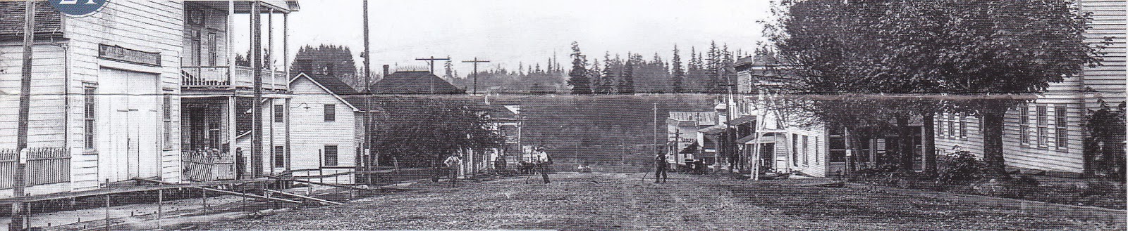
One historical image provided by the Aurora Colony Museum (below) shows Main Street in 1908. Several of the original buildings still stand today.


For comparison, a photo of Main Street taken in 2014:


In both photos, the WM Keil and Company Store stands distinctively on the left.....

Wm Keil and Company Store

next to the William Fry House:

William Fry House

William Fry (1835-1906), from Pennsylvania, was a blacksmith who settled in Aurora with his wife Annie and their four children.

Across the street was the Will-Snyder Store, built in 1912:

Will-Snyder Store

Other buildings that no longer exist include the Aurora Colony Drugstore, which was torn down in 1962 and Aurora Colony Store, which was torn down in 1931 to make room for Highway 99 East that now runs through the middle of town. At one time an impressive hotel also stood near the railroad tracks called the Aurora Pioneer Hotel (1867-1934). A historical photo of the hotel can be seen on the Canby Historical Society web page. The only surviving building from the hotel complex is an octagon building located off 2nd Street. The historical use of the building is unknown.

Aurora Pioneer Hotel Octagon Building

The home of Jacob Miley (1838-1907) stands near the railroad tracks behind the Walter Fry house. Jacob was a settler from Ohio and built this home in 1867:

Jacob Miley House

The Walter Fry (1882-1974) House still stands on Main Street:

Walter Fry House

The Southern Pacific Railroad Depot is currently just adjacent to Walter Fry's home. It was formerly located near the old mill and relocated in 1990. Aurora was an agricultural town known mainly for hops, dairy and filberts. The food was also acclaimed as known from an article in the Portland newspaper, The Oregonian, which praised the fried potatoes, pig sausage, smoked ham, bread, cottage cheese, candies, jellies, and cakes... (Sreenivasan, J, 2008). Visitors were greeted by the community band which played on the roof of the Aurora Pioneer Hotel.

Aurora Depot

The Aurora State Bank building came from the Lewis and Clark Centennial Exposition in Portland and was relocated to Aurora in 1905. Lyn Topinka provides postcard images of the exposition. The bank's two original vaults remain, but are now used by a local winery which uses the building for its tasting room:

Aurora State Bank Building

The colony warehouse, or Ziegler's Warehouse, still remains and is currently used as an architectural salvage business. The remains of a grist mill are located in 1st Street adjacent to the warehouse (no photo). It was built by David Smith who was born in Ohio and came to Oregon in 1851. The grist mill was built in 1853 and destroyed by fire. Another was built the same year. Smith sold it in 1856 and moved to Yamhill County.  

Ziegler's Warehouse

Jacob Miller (1837-1916) was one of the original colonists. His house was built in 1889 and is located across the street from the Aurora Colony Museum:

Jacob Miller House

Finally, the current location of The Old Aurora Colony Museum is in an old ox barn on 2nd and Liberty Streets. The building was later converted to a store, and then to the museum.

Old Aurora Colony Museum Oregon
Old Aurora Colony Museum

Museum Interior

4/04/2014

The Secret to Germinating Milkweed!

Advice for Germinating Milkweed Seeds: I originally bought some milkweed seeds and knew nothing about getting them to germinate. Why would I want to grow milkweed? I want to provide host plants for the Monarch butterfly, the population of which has declined dramatically in recent years. Milkweed is essential for reproduction of Monarch butterflies. It is the ONLY plant on which the butterflies will lay their eggs.

On my first attempt at germinating the seeds, I just put them into soil straight from the package, watered, and waited... nothing. The next year, I bought a couple of plants from a native plant nursery, planted them, and collected seeds in the fall. Around January, I cold stratified the seeds in the refrigerator for about 6-8 weeks.

This requires wetting a paper towel and wringing out all the water, placing the seeds between two pieces of damp paper towel, and placing the "sandwich" of seeds in a Ziploc bag. I threw the bag in the refrigerator and waited. In late February, I gently scarified the seeds with some sandpaper, placed them in some soil, and voila! near perfect germination.


4/03/2014

Vegan Jackfruit Carnitas Tacos

Vegan Recipes - Jackfruit Carnitas Tacos. I tried this great recipe the other day. The amount and combination of spices in this particular recipe was just right, and the outcome was really awesome. I want to post the original link and provide another source for the recipe here on my blog. My photos aren't as nice as on the original website, but you get the idea. Jackfruit is native to Southeast Asia and you can buy it canned in salt and water at your local Asian market. It is quite commonly used in vegan recipes as a substitute for meat because, when cooked, it shreds into meat-like fibers.


I fried the carnitas in a cast-iron skillet adding more oil when it became a bit too dry. The idea is to fry it long enough to get the edges a bit crispy. The maple syrup helps with this. I was really impressed with the result.


Jackfruit Carnitas Tacos

Ingredients:
Spice Blend:
2 tsp ground cumin
2 tsp chili powder
pinch cayenne pepper
1/4 tsp paprika
1/2 tsp oregano
1/4 tsp garlic powder
1/4 tsp pepper
1/2 tsp salt
pinch cinnamon
1 tsp lime juice

For the carnitas:
1 Tbsp cooking oil (Canola or something neutral)
1 small onion, diced
2 clove garlic, crushed
Homemade spice blend (see above)
1 20 oz can of Jackfruit in brine, drained
1 Tbsp maple syrup

Directions:
Place a pan on medium heat. Add oil, onion, garlic, and spice blend. Stir until onions are clear and coated with spices. Add jackfruit and maple syrup and stir occasionally to break up the jackfruit. It will be ready when the liquid is dissolved and the jackfruit darkens and starts to look like shredded meat.

1/11/2014

Oregon Coast: Cape Perpetua

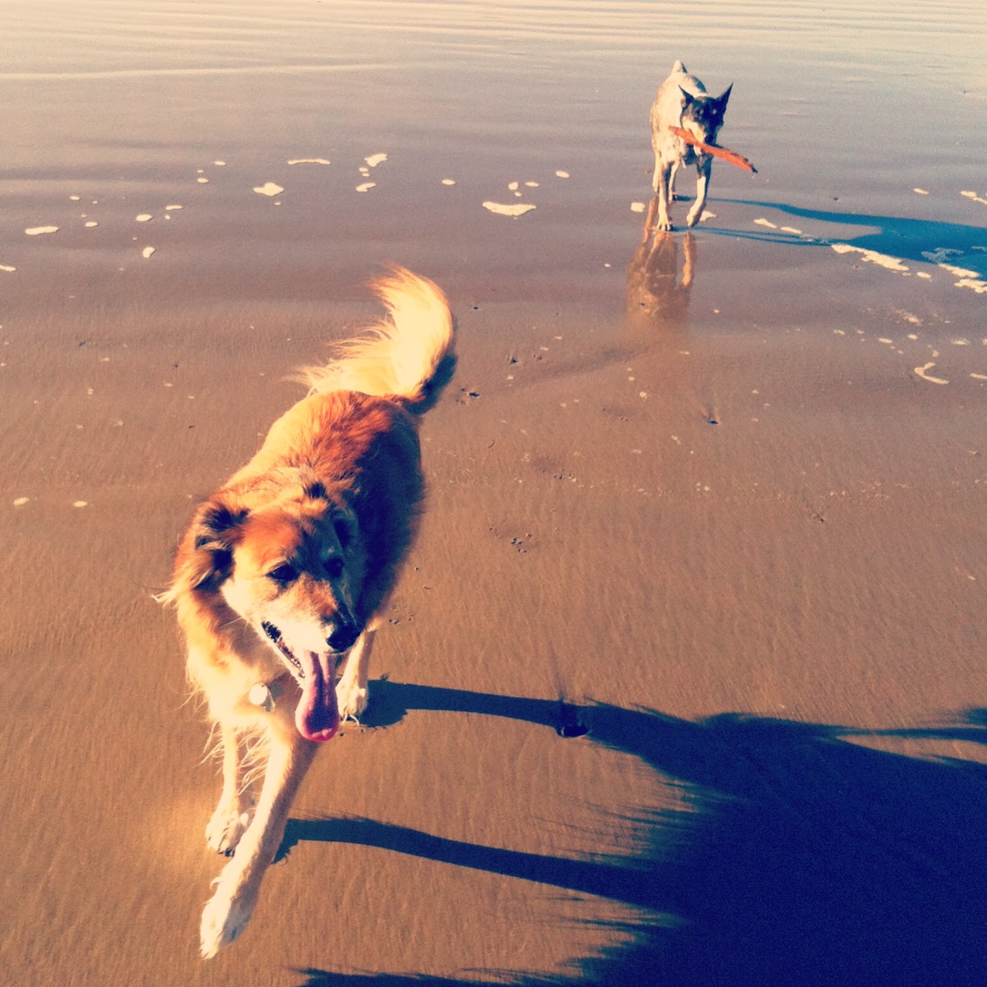
The Oregon coast can get really crowded during the summer, so we decided to explore a new area during the Christmas holiday. We loaded up the Pony and headed west. We had not previously been south of Lincoln City and decided to explore Waldport, Yachats, Cape Perpetua and Heceta Head. After lunch at Georgie's Beachside Grill in Newport, our first order of business was play time on the beach at Tillicum Beach Campground where we intended to spend the night. The campground is near Yachats, which is a village located about 24 miles south of Newport at the mouth of the Yachats River. It was doggie heaven...


The campground is located right next to the beach and several of the camp sites have beach views. You will find it on the west side of the highway 4 miles south of Waldport. The next morning we headed to the Devil's Churn day use area to view a coastal inlet known as Devil's Churn. Devil's Churn is an 80 foot wide volcanic chasm where the waves crash and are thrown several hundred feet into the air when the tide comes in. The tide was heading out while we were there.


After walking the 0.4 mile "Trail of the Restless Waters" (to Devil's Churn), we headed a couple of miles south to nearby Cape Perpetua. There is also a hiking trail that leads to this lookout point but we were pressed for time and drove. The St. Perpetua hiking trail is 2.6 miles and starts at the Cape Perpetua Visitors Center. To drive up, head east on Forest Service Road 55, then left on a secondary Forest Service Road 5553.

Captain James Cook was the first to discover this site in 1778 and named it after Saint Perpetua. It is the highest lookout point on the Oregon Coast at 800 feet above the shoreline.


In 1933, under President Roosevelt, the site became a base camp for the Civilian Conservation Corps (CCC) which built a stone shelter for recreational purposes. The shelter provides a spectacular view of the Oregon coastline and is a popular viewpoint for whale watching. A walking loop will lead you there.


Just south of the Cape Perpetua Visitor Center, west of Highway 101 is a great location for exploring tide pools.


Our final stop was Heceta Head Lightstation north of Florence. The site of this lighthouse is stunning, and the former Keeper's House has been converted to a Bed and Breakfast. Originally, there were two lightkeepers' houses at the site. In the late 1930s the Head Keeper's dwelling was sold for $10 and the salvaged lumber was transported to Mapletown to build what is now the Alpha Bit Store and Cafe. Both were Queen Anne-style homes.


The actual lighthouse was first used on March 30, 1894 to guide ships up and down the rocky coast. In 1963, it was automated and converted from a kerosene wick to a 1000 Watt bulb. State park volunteers provide free tours (option to donate) and public parking is $5 per vehicle.


12/08/2013

City Trip: Vancouver, British Columbia, Canada

An Adventure in Canadian Microbrews (and more): We thought it would be a great idea to avoid the Black Friday Thanksgiving shoppers by taking the Amtrak north to Vancouver for the weekend. We expected a rainy trip and so made plans to explore the indoor attractions such as the highly recommended Museum of Anthropology and Museum of Modern Art. Besides, I had never really taken a trip by Amtrak and wanted to see what the experience is like. We arrived in Vancouver about one and a half hours late, enduring a trip that would have taken half the time in a car. I have to admit the views are much nicer than the freeway experience, and it is great to be able to walk around. Everything was positive about the experience except for the travel time. It is very slow.

We arrived at our destination in the Robson Area at 1:00 am. The next morning we took to the streets. The Robson area is Vancouver's busiest shopping and dining area. Vancouver is a very international city with an incredible number of shops and restaurants from nearly every part of the globe.


We caught the 044 bus on Burrard Street to the Museum of Anthropology located on the University of British Columbia campus. This museum contains one of the largest collections of Northwest Coast First Nations art. Native art is not my favorite, but there was a vast collection of work from the late Bill Reid, a Haida (HIGH-dah) artist. The Haida are indigenous people from the Pacific Northwest Coast of North America from Canada through Alaska. They were a fishing community that relied heavily on salmon. Many of the dugout canoes, woven baskets, and bentwood boxes for which they are known were on display. Tribal art from other parts of the world were on exhibit as well. Photos were permitted, and the museum provides free guided tours.


Touring the museum took a large part of the afternoon but on the way back to Robson area we stopped at Point Grey to see the oldest building in Vancouver, the Hastings Mill Store. It was closed!! I was really disappointed. Apparently it contains more tribal relics and some historical logging photographs. At least I got to see a beautiful view of the Strait of Georgia.


We headed back to the shopping district to try some food and sample some Canadian microbrews. We stopped at the nearby Winking Judge Pub and sampled the Devil's Elbow IPA (Howe Sound Inn & Brewing Company, 5.7% ABV, 68 IBUs). The actual brewery is in Squamish, BC which is about 45 minutes north of Vancouver. We also sampled Scandal Ale, an organic beer brewed by Scandal Brewing Company located in Prince George, BC 8.5 hours north of Vancouver (5% ABV, 17 IBUs). Afterwards, we settled on a small Asian noodle bowl restaurant and found it very delicious.


The next day, we decided to check out the Vancouver Art Gallery, Vancouver Police Museum, and walk around the Chinatown and Gastown areas. The art gallery was interesting but many of the "modern" art exhibits were from the 70s. I felt that it was a little dated and needed some fresh (more current) exhibits. No photos permitted of course. We moved on to the Vancouver Police Museum and found it very interesting. The museum was located in the old coroner's building and contained a wide display of contraband (weapons, drugs, etc.), evidence from murder scenes, historical police uniforms, and other intriguing artifacts from Vancouver's criminal underworld.


After completing the tour, we headed over to Chinatown. It was interesting to check out all of the unique foods and souvenirs for sale in the markets. After a stroll through the 2 x 4 block area, we headed to Gastown, a national historical site in Vancouver. This was my favorite area.


Gastown was Vancouver's oldest neighborhood established in 1867. The architecture and layout of the area was beautiful. I am not surprised it was named 4th Most Stylish Neighbourhood in the World in 2012. There is a faux steam-powered clock, restored for tourism. The Gastown Steam Clock is located on the corner of Cambie and Water Street and was originally built to cover a steam grate. It was built to harness the steam and to prevent street people from sleeping on the spot in cold weather. 


This trip was short and we were at the end of our last day. We decided to get out of the rain and sample some more Canadian microbrews. First stop was Yale Town Brewing Company where we sampled Yale Town beers. Here's the list:

Yale Town Warehouse Stout on nitro (4.5% ABV)
Yale Town Brick & Beam IPA (5.8% ABV, IBUs?) 
Yale Town Downtown Brown, English Brown Ale on nitro 
Yale Town Nagila Pale Ale (5% ABV)

At another pub, we sampled beers from Granville Island Brewing Company and Driftwood Brewery including:

Granville Island English Pale Ale (5% ABV, 18 IBUs)
Driftwood Fat Tug IPA (7% ABV, 80 IBUs)

Onward to Steamworks Brewing Company! Wow, writing this down, I can't believe we drank all this beer.

Heroica Oatmeal Stout (5% ABV, 35 IBUs)
Empress IPA (5% ABV, IBUs?)

We stopped in another pub where we were lucky enough to catch the end to the Arkansas/Auburn football game. We sampled from Parallel 49 Brewing, Red Truck Brewery, and Russell Brewing Company.

Parallel 49 Milk Stout (ABV 4.2%, 14 IBUs)
Red Truck Ale (5.2% ABV, IBUs?)
Red Truck Cask Strength Ale
Russell Wee Angry Scotch Ale (6.5% ABV, 30 IBUs)
We tasted the Belgian Delirium Tremens, Belgian Blond Ale (8.5% ABV)

The next day was all travel, leaving Vancouver at 6:00 am. It was a great trip!